
Back-to-Back Arctic Blasts Set to Lock Much of the Eastern United States in Prolonged Deep Freeze Into Early February
UNITED STATES — Forecast models are signaling a rare and extended cold weather pattern developing across a large portion of the eastern United States, with back-to-back Arctic outbreaks expected to drive temperatures 15 to more than 30 degrees below normal from late January into early February.
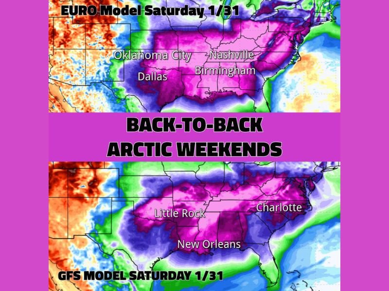
Meteorological guidance shows the cold intensifying again late next week into the following weekend (January 30 through February 3), following an already significant Arctic intrusion. The persistence of this pattern is unusual, with cold air remaining entrenched rather than quickly retreating.
Widespread Below-Normal Temperatures Across Central and Eastern States
Model data highlights a broad region of significantly colder-than-average temperatures stretching from the Southern Plains through the Midwest, Ohio Valley, Southeast, and into the Mid-Atlantic.
Areas including Texas, Oklahoma, Arkansas, Tennessee, Alabama, Mississippi, Georgia, the Carolinas, and parts of the Midwest are shown in the core of the cold signal, with many locations expected to remain well below seasonal norms for several consecutive days.
Cities indicated within the coldest anomalies include Dallas, Oklahoma City, Little Rock, Nashville, Birmingham, New Orleans, and Charlotte, underscoring how far south the Arctic air is projected to reach.
Snow and Ice Pack Expected to Reinforce the Cold
A key factor prolonging the chill is the existing and expanding snow and ice cover across large sections of the country. With snowpack reflecting sunlight and limiting daytime warming, temperatures are expected to struggle to recover even during daylight hours, particularly through midweek.
This setup favors cold mornings, suppressed daytime highs, and continued risk of icy conditions, especially in regions that have already experienced winter precipitation.
Another Arctic Front Likely to Reinforce the Cold Late Next Week
By late next week, forecast guidance shows another strong Arctic front dropping south, reinforcing the cold air already in place. While models have backed off slightly on a major southern winter storm, forecasters note that a weaker signal still exists and bears watching as the pattern evolves.
Even without a major storm, temperatures are expected to remain significantly below average into next weekend, keeping much of the eastern half of the country locked in a prolonged deep freeze.
What This Means Moving Forward
The developing pattern suggests little relief from the cold heading into early February, increasing concerns over energy demand, frozen pipes, travel issues, and cold-related health risks. Residents across affected regions are encouraged to prepare for extended cold, monitor updates closely, and take precautions to protect homes, vehicles, and vulnerable individuals.
How cold is it expected to get in your area as this pattern unfolds? Share your thoughts and stay informed with continued weather coverage at NapervilleLocal.com.

I’ve lived in Naperville long enough to see how quickly our community changes — from new developments downtown to sudden shifts in our Midwest weather. Reporting on Naperville news and daily forecasts gives me the chance to keep neighbors informed about what really matters. My goal is simple: deliver clear, timely updates so you always know what’s happening in our city and what to expect from the skies above.