
Birmingham, Huntsville, Montgomery, Mobile See Sunny Sunday 70s Before Alabama Warms Into 80s and Tracks Late Week Rain and Early April Cooldown Risk
ALABAMA — A classic spring setup is unfolding across the state, starting with a warm and sunny Sunday before transitioning into even warmer temperatures and increasing rain chances later in the week. Forecast data shows highs reaching the 70s statewide Sunday, offering a comfortable and pleasant end to the weekend.
Sunny Sunday Brings Ideal Spring Conditions
Most of Alabama, including Birmingham, Huntsville, Montgomery, and Mobile, will enjoy:
- Plenty of sunshine
- Mild and comfortable afternoon highs in the 70s
- Light winds and dry conditions
This creates one of the most enjoyable weather days in recent weeks, with no severe weather concerns.
Warmer Air Builds Into the 80s This Week
Heading into the workweek, temperatures will trend even warmer:
- Highs climb into the upper 70s and low 80s
- Increasing humidity levels across the region
- A noticeable shift toward a more typical late spring pattern
This warming trend is driven by southerly flow bringing moisture back into the Southeast.
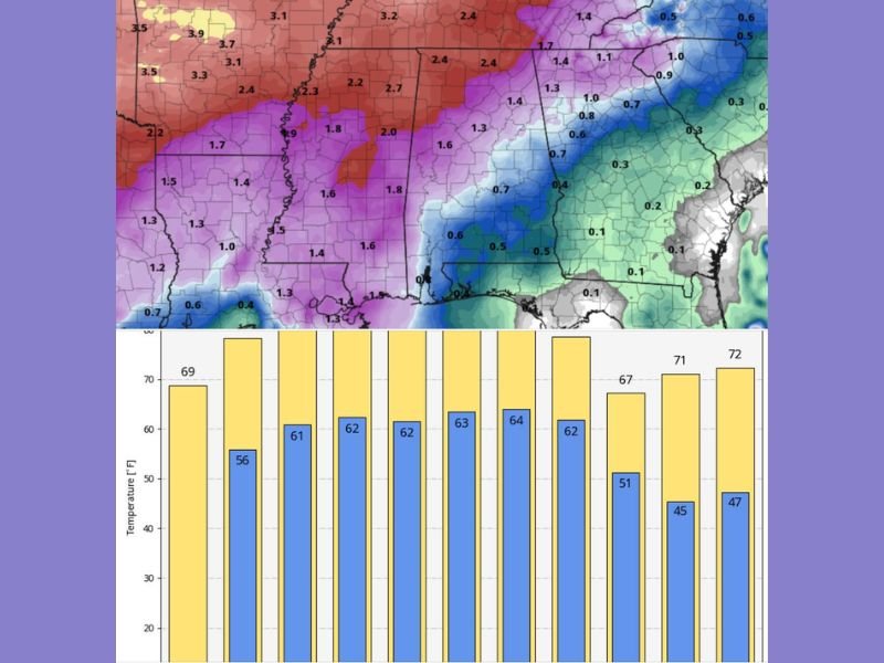
Rain Chances Gradually Increase Late Week
While the early part of the week remains mostly dry, changes begin to develop by mid-to-late week:
- Scattered showers become more likely
- Rain coverage increases, especially in northern and western Alabama
- Higher rainfall totals expected in those regions
Importantly, current projections show no significant severe weather risk at this time, with storms expected to remain more of the garden-variety type.
Rainfall Focus Strongest in Northern and Western Areas
Forecast models highlight a gradient in rainfall across the state:
- Heavier totals (1.5 to 3+ inches) possible in northwest Alabama
- Moderate rainfall across central regions
- Lighter totals expected toward southeastern areas
This uneven distribution reflects how incoming systems will track across the region.
Early April Cooldown Could Follow Warm Stretch
Looking beyond the upcoming week, longer-range guidance suggests:
- A cold front arriving around April 6–8
- A shift back to cooler temperatures
- Potential for a late-season chill or even patchy frost
While details remain uncertain, this indicates that winter may not be completely finished just yet.
What This Means for Alabama Residents
The overall pattern highlights a typical spring transition:
- Enjoyable and warm conditions early in the week
- Increasing clouds and rain chances later on
- A possible cooldown as we move into early April
Residents should take advantage of the sunny and mild weather now while preparing for wetter conditions ahead. Stay with NapervilleLocal.com for continued updates as Alabama’s evolving spring weather pattern brings warmth, rain, and potential early April changes.

I’ve lived in Naperville long enough to see how quickly our community changes — from new developments downtown to sudden shifts in our Midwest weather. Reporting on Naperville news and daily forecasts gives me the chance to keep neighbors informed about what really matters. My goal is simple: deliver clear, timely updates so you always know what’s happening in our city and what to expect from the skies above.