
Blockbuster Northeast Blizzard Threatens I-95 From Philadelphia to Boston Sunday Into Monday With Up to Two Feet and 60–70 MPH Gusts
UNITED STATES — A high-impact “blockbuster” blizzard is being forecast to strike the Northeast from Sunday into Monday, with the potential to bury major cities along the I-95 corridor and create dangerous travel conditions from the Mid-Atlantic into New England. The forecast messaging warns this could be one of the most disruptive winter storms in years, with heavy snowfall, near-zero visibility at times, and wind gusts strong enough to trigger scattered power outages.
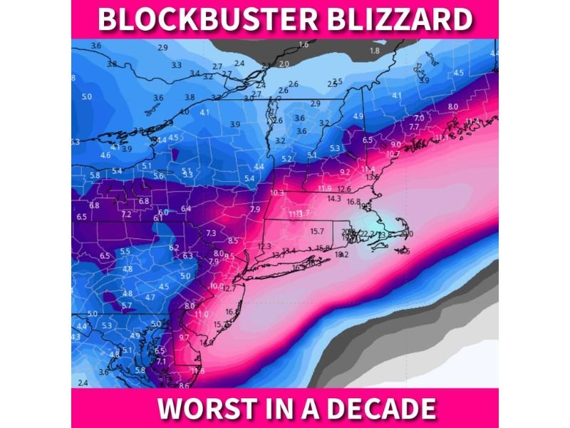
The outlook specifically highlights Philadelphia, New York City, and Boston as cities at risk for the heaviest snow, with totals potentially reaching one to two feet in the core of the storm. The accompanying map shows a swath of the highest snow potential aligned near the coast and I-95, where a stronger coastal low typically concentrates moisture and creates intense snow bands.
Snowfall and Blizzard Conditions: What’s Being Forecast
The biggest concern is the combination of heavy snow and powerful winds. Forecast discussion notes 60–70 mph wind gusts are possible, a level that can significantly reduce visibility and lead to true blizzard or near-blizzard conditions where snow is falling and blowing at the same time. When gusts reach that range, even well-plowed roadways can quickly become covered again as snow drifts and piles back into travel lanes.
In coastal storms, snowfall rates can also spike within narrow bands. If those bands set up over metro areas, conditions can deteriorate quickly with rapid accumulation on roads, ramps, and bridges.
Where the Impacts Look Strongest
The core impact zone is focused along the I-95 spine, where the storm could create the worst mix of heavy snow and wind. In addition to Philadelphia, New York City, and Boston, the broader risk extends through New Jersey, Connecticut, Rhode Island, and Massachusetts, with impacts likely expanding inland as well depending on the final track. The guidance indicates the coastal strip is most vulnerable to the highest totals, while areas farther inland may still see disruptive snow but could end up on the lower side if the storm stays more offshore.
Travel Disruptions and Power Outage Risk
This storm is expected to cause major travel problems for the region. Heavy snow and low visibility can lead to highway closures and spinouts, especially on elevated roadways and coastal routes. The forecast also warns of major airport disruptions. That can mean delays, cancellations, and difficulties with de-icing operations if snowfall becomes intense and winds increase.
Power outages are a real concern as well, particularly if wind gusts peak while snow is accumulating on trees and lines.
What Residents Should Do Now
If you live anywhere from the Mid-Atlantic to New England, plan for a high-impact period Sunday into Monday. Keep travel flexible, monitor local alerts, and prepare for the possibility of extended delays and limited road access during the worst conditions.

I’ve lived in Naperville long enough to see how quickly our community changes — from new developments downtown to sudden shifts in our Midwest weather. Reporting on Naperville news and daily forecasts gives me the chance to keep neighbors informed about what really matters. My goal is simple: deliver clear, timely updates so you always know what’s happening in our city and what to expect from the skies above.