
California Braces for Flood Risk as Powerful Storm and Atmospheric River Arrive Thursday
CALIFORNIA — A powerful Pacific storm system is forecast to move into California late Wednesday, November 12, bringing widespread rain, flooding risks, and even mountain snow as it intensifies through Thursday, November 13.
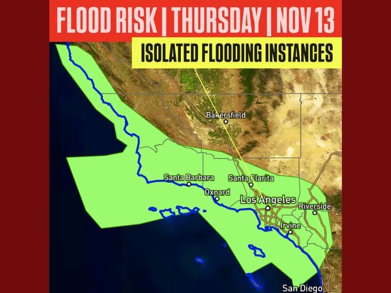
Heavy Rain Expected Across Central and Southern California
Meteorologists say the system will tap into an atmospheric river, a narrow corridor of moisture streaming in from the Pacific Ocean, leading to prolonged and heavy rainfall across the state.
The flood risk begins Wednesday across Northern California’s coastal areas, then spreads south into the Central Coast and Southern California by Thursday morning.
Forecast models highlight Santa Barbara, Los Angeles, Ventura, and San Diego Counties as areas with a higher potential for localized flooding and mudslides, particularly near recent wildfire burn scars.
“Localized flooding is possible, with the greatest concern near recent burn scars where flash flooding and debris flows could occur,” meteorologists warned.
Urban and Burn-Scar Areas Face Greatest Risk
The National Weather Service cautions that urban areas with dense concrete and poor drainage systems could also experience flooding, especially during periods of intense rainfall.
Forecasters note that mudslides, rockslides, and road flooding may occur in hillside communities, while flash flooding remains a key concern in canyons and low-lying zones.
Communities recently impacted by wildfires—including parts of Santa Clarita, Malibu, and Oxnard—are being advised to stay alert for rapid water accumulation and debris flows.
Snow Likely in Higher Elevations
Along with heavy rain, colder air aloft will bring accumulating snow to higher elevations of the Sierra Nevada and the mountains surrounding Los Angeles County. Snow levels may drop to around 6,000 feet, with travel impacts expected on mountain passes late Thursday.
Flooding Risk to Increase as Storm Strengthens
The storm’s intensity may increase as it moves inland Thursday night, with rainfall totals ranging between 1–3 inches for coastal and valley regions and 4–6 inches possible in higher terrain.
Emergency management agencies across the state are urging residents to avoid driving through flooded roadways and to prepare for potential power outages or evacuation notices in high-risk areas.
Officials Urge Preparedness
Local officials recommend keeping sandbags and emergency supplies on hand and checking weather updates frequently as the system approaches.
“It’s likely this flood risk will increase as the storm nears,” forecasters said. “Snow is also likely for the higher elevations.”
Residents are advised to monitor updates from the National Weather Service and local emergency offices throughout the week.
For ongoing updates on California weather alerts and flood advisories, visit NapervilleLocal.com.

I’ve lived in Naperville long enough to see how quickly our community changes — from new developments downtown to sudden shifts in our Midwest weather. Reporting on Naperville news and daily forecasts gives me the chance to keep neighbors informed about what really matters. My goal is simple: deliver clear, timely updates so you always know what’s happening in our city and what to expect from the skies above.