
California Faces Low-End Severe Weather Threat With Potential for Waterspouts, Brief Tornadoes, and Damaging Wind Gusts From Tuesday Night Into Christmas Morning
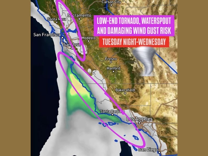
California — A developing West Coast storm system combined with an atmospheric river will bring a low-end severe weather risk to parts of California beginning Tuesday night and continuing through Christmas Eve, with some impacts possibly lingering into early Christmas morning. Forecasters warn that conditions may support brief waterspouts, isolated tornadoes, and damaging wind gusts along the central and Southern California coast and through portions of the Central Valley.
Atmospheric River and West Coast Trough Create Unstable Weather Setup
Meteorologists explain that the incoming system will place parts of California in the “left-exit region” of a powerful upper-level trough, a zone known to enhance upward motion and storm development. While overall instability will be modest, the presence of adequate low-level and deep-layer wind shear may compensate for limited thunderstorm energy.
This combination could allow low-topped supercells to form, producing:
- A brief tornado or waterspout
- Localized damaging wind gusts
- Fast-moving convective showers
Forecasters emphasize that the severe risk remains low, but not zero, especially given the dynamics associated with the atmospheric river feeding into the system.
Regions Most at Risk for Severe Weather
Areas highlighted for potential impacts include:
- Central California coast, including San Francisco to Monterey
- Southern California coast from Santa Barbara to San Diego
- Parts of the Central Valley, including Fresno and Hanford
These regions may experience rapidly changing conditions as moisture, wind shear, and terrain-driven circulation interact. Brief spin-ups along the coastline are possible, especially overnight when small, fast-moving cells move ashore.
The atmospheric river portion of the system will also bring periods of heavy rain, which could reduce visibility and create slick travel conditions during holiday travel windows.
Holiday Travel and Safety Considerations
With the risk window falling between Tuesday night and early Christmas morning, meteorologists advise residents to monitor updates closely. Even a low-end severe event can produce dangerous localized conditions, particularly for those driving at night or along exposed coastal routes.
Residents should remain aware of:
- Gusty winds capable of downing small branches
- Sudden bursts of heavy rain
- Waterspout formation near or offshore
- Rapidly shifting wind direction near thunderstorms
Officials recommend staying weather-aware, especially if Christmas travel plans include long-distance driving across the state or along the coast.
Looking Ahead
The system is expected to move eastward after Christmas Morning, but forecasters note the possibility of additional unsettled weather returning later in the week. More detailed updates will be issued as new model data becomes available. For continued coverage of California’s holiday weather impacts and nationwide forecasts, visit NapervilleLocal.com for the latest updates.

I’ve lived in Naperville long enough to see how quickly our community changes — from new developments downtown to sudden shifts in our Midwest weather. Reporting on Naperville news and daily forecasts gives me the chance to keep neighbors informed about what really matters. My goal is simple: deliver clear, timely updates so you always know what’s happening in our city and what to expect from the skies above.