
California, Oregon, and Washington Face Massive Atmospheric River as ISS Captures Enormous Storm Bands Over the Pacific
WASHINGTON — A massive atmospheric river stretching hundreds of miles across the Pacific Ocean is pushing directly toward the West Coast, with cloud bands so large they were photographed from the International Space Station. The storm is funneling deep tropical moisture toward California, Oregon, and Washington, setting the stage for days of heavy rain, flooding, and dangerous travel conditions.
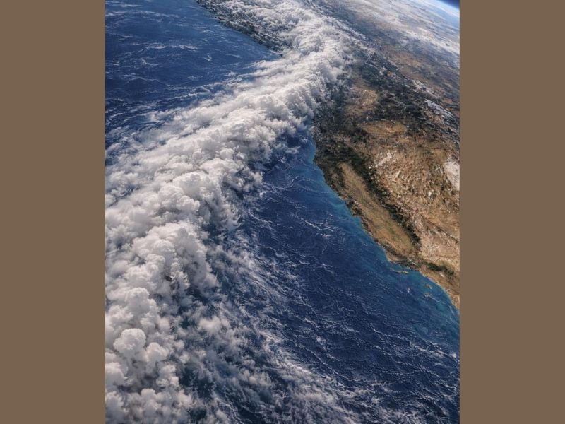
ISS Imagery Shows the Enormous Scale of the Incoming Storm
Astronaut images show a sweeping plume of thick, towering clouds stretching across vast sections of the ocean — a visual indicator of a highly energized atmospheric river. Forecasters say the storm is carrying an unusually high amount of water vapor, similar to past systems that produced widespread flooding across coastal and inland regions.
The atmospheric river is expected to produce continuous waves of rain, increasing the likelihood of:
- Urban and small-stream flooding
- Rapid rises in river levels
- Landslides in mountainous areas
- Travel delays and hazardous road conditions
West Coast Prepares for Flooding, Power Outages, and Travel Hazards
Weather officials warn that California’s central coast and Sierra foothills, along with western Oregon and western Washington, may see the heaviest impacts as the system moves inland. Saturated ground from recent storms increases the risk of mudflows and debris slides, particularly in burn-scarred areas.
Strong winds along the coastline could also contribute to power outages, falling trees, and difficult marine conditions.
Experts Say the Storm’s Scale Would Be Catastrophic on the East Coast
Meteorologists note that if a storm of this magnitude formed on the East Coast, millions of residents from Florida to New York City and into New England would face widespread disruption, torrential rainfall, flash flooding, and major infrastructure strain.
While the West Coast is more accustomed to atmospheric river events, the sheer size of this system has prompted heightened alerts and emergency monitoring.
Communities Urged to Stay Prepared
Officials are advising residents in flood-prone regions to:
- Monitor local forecasts and alerts
- Avoid travel during peak rainfall periods
- Keep emergency kits ready
- Stay clear of swollen rivers and drainage areas
More updates are expected as the system approaches land and intensifies. For continuing severe weather coverage, follow NapervilleLocal.com.

I’ve lived in Naperville long enough to see how quickly our community changes — from new developments downtown to sudden shifts in our Midwest weather. Reporting on Naperville news and daily forecasts gives me the chance to keep neighbors informed about what really matters. My goal is simple: deliver clear, timely updates so you always know what’s happening in our city and what to expect from the skies above.