
California, Oregon, Arizona, and Nevada Prepare for Widespread Rain as Powerful West Coast Storm Arrives Tuesday Night
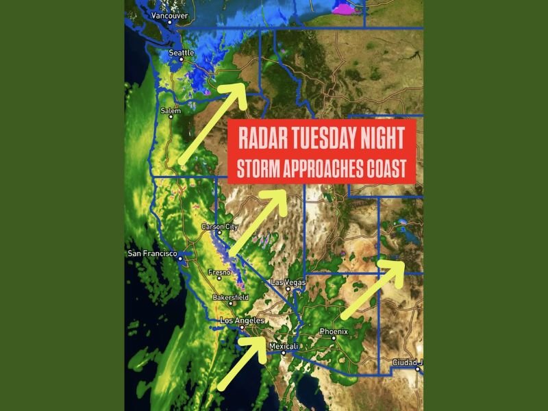
WEST COAST — A powerful storm system is expected to light up radar across California, Oregon, Arizona, and Nevada on Tuesday night, delivering widespread rain, mountain snow, and strong winds as it pushes inland from the Pacific. Forecasters say the approaching system will be highly visible on radar, with precipitation expanding rapidly along the coast before spreading into the Desert Southwest within just over 24 hours.
Satellite and radar projections show the storm strengthening offshore throughout the day Tuesday before making its move toward the coastline by evening. As moisture surges inland, the first impacts will be felt along the California coastline near San Francisco, Los Angeles, and the Central Valley, where bands of rain and embedded heavier pockets are expected to develop quickly.
Heavy Rain Expands North and East Overnight
Meteorologists predict that Oregon’s coastline and interior valleys will see widespread rainfall as the storm moves north. The radar depiction shows a large, organized area of moisture pushing into Salem, Portland, and the surrounding regions, making for a wet and unsettled Tuesday night.
Further east, precipitation will spread into Nevada, including the Reno and Las Vegas areas, where moderate rainfall is expected. Meanwhile, Arizona will begin to see scattered rain showers streaming in from the west late Tuesday night, reaching cities such as Phoenix as the system continues to expand.
Storm Will Resemble a “Christmas Tree” on Radar
Forecasters noted that the storm will create a striking radar image, with widespread areas of green, yellow, and heavier rain signatures resembling a “Christmas tree” across much of the West. This visual effect highlights the storm’s size and intensity as it sweeps across multiple states.
Travel Impacts Likely Across the Region
The storm’s arrival is expected to produce several travel-related challenges, especially for holiday commuters. Key concerns include:
• Heavy rain reducing visibility on major highways in California and Oregon
• Slippery roads across Nevada and Arizona as moisture spreads inland
• Delays possible at major airports including LAX, SFO, and PHX
• Mountain areas potentially receiving snow, affecting passes and higher-elevation routes
While this system will bring beneficial moisture to much of the region, residents and travelers should prepare for rapidly changing conditions Tuesday night into Wednesday. Stay connected with NapervilleLocal.com for continuing weather updates, storm coverage, and safety information.

I’ve lived in Naperville long enough to see how quickly our community changes — from new developments downtown to sudden shifts in our Midwest weather. Reporting on Naperville news and daily forecasts gives me the chance to keep neighbors informed about what really matters. My goal is simple: deliver clear, timely updates so you always know what’s happening in our city and what to expect from the skies above.