
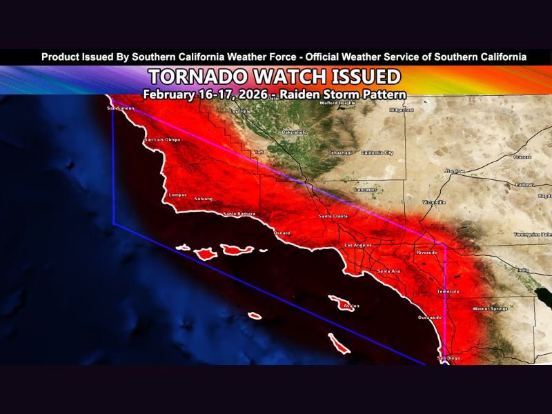
California Tornado Watch Issued for Los Angeles, San Diego and Coastal Counties as Powerful Storm Line Targets Southern California Monday Into Tuesday
Los Angeles, California — A Tornado Watch has been issued for large portions of Metro Southern California as a powerful and potentially dangerous storm system moves into the region Monday and continues into Tuesday.
Southern California Weather Force announced the watch will cover San Luis Obispo, Santa Barbara, Ventura, Los Angeles, Orange, and San Diego counties, including parts of the Inland Empire. The alert signals that atmospheric conditions are favorable for tornado development, along with other severe weather hazards.
Storm Line Moving West to East Across the Watch Area
Forecasters indicate that a strong line of storms will begin impacting areas west of Los Angeles before pushing eastward across the entire watch zone. Unlike a simple cold front, this system is expected to feature active thunderstorms embedded within the line.
That setup increases the risk of:
- Damaging wind gusts
- Isolated tornadoes
- Large hail
- Heavy rainfall and localized flooding
Meteorologists describe this as a storm line that “means business,” suggesting multiple rounds of severe weather are possible rather than a brief passing event.
Multiple Rounds of Severe Weather Possible
The first round is expected with Monday’s frontal passage, bringing strong winds and thunderstorms across coastal and inland areas.
However, forecasters warn that this will not be a one-and-done system.
A secondary round of storms may redevelop later Monday after the main front passes. Another push of unsettled weather could continue overnight into Tuesday, prolonging the risk window.
This extended timeline increases the importance of staying weather-aware across the region.
Mountain Travel Concerns and Thundersnow Risk
In addition to severe storms near the coast and inland valleys, mountain areas face different but equally serious concerns. Thunderstorms at elevation could produce thundersnow, along with heavy snowfall.
Officials caution that travel in mountainous areas could become dangerous or even impossible if snowfall intensifies. Residents and visitors in higher elevations are being urged to avoid unnecessary travel and to leave early if conditions begin to deteriorate.
Flooding and Debris Flow Risk in Burn Scar Areas
Southern California remains vulnerable to flooding and debris flows, especially in burn scar zones from past wildfires. Heavy downpours could quickly trigger mudslides or rapid runoff in these areas.
Urban flooding is also possible in cities such as Los Angeles, Santa Ana, Riverside, and San Diego if intense rainfall rates develop within thunderstorms.
What Residents Should Do Now
A Tornado Watch does not mean a tornado is occurring, but it does mean conditions are favorable. Residents across the watch area should:
- Monitor weather updates closely
- Have multiple ways to receive warnings overnight
- Secure loose outdoor items
- Prepare for possible power outages
With damaging winds, heavy rain, hail, and isolated tornadoes all possible, Southern California faces a high-impact weather period beginning Monday and lasting into early Tuesday.
For continued national severe weather updates and storm coverage affecting communities across the country, follow daily reports on NapervilleLocal.com.

I’ve lived in Naperville long enough to see how quickly our community changes — from new developments downtown to sudden shifts in our Midwest weather. Reporting on Naperville news and daily forecasts gives me the chance to keep neighbors informed about what really matters. My goal is simple: deliver clear, timely updates so you always know what’s happening in our city and what to expect from the skies above.