
California Weather Alert: Baja Low Brings Low-End Thunderstorm Risk to Southern California Mountains Tonight and Friday
CALIFORNIA — A low-end thunderstorm risk is setting up for Southern California tonight and Friday, especially over higher terrain, as a Baja Low moves closer to the coast and pushes a plume of high-level moisture, added lift, and elevated instability into the region. While dry mid-level air could limit how much rain actually falls, forecasters say a storm or two can’t be ruled out, with the best chance Friday afternoon into Friday evening.
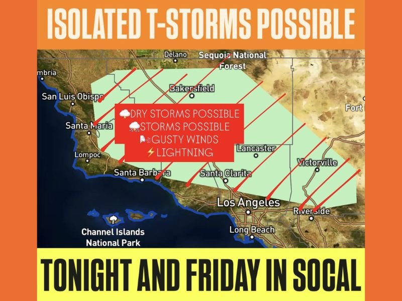
What the map shows and which Southern California areas are included
The graphic highlights a broad zone of isolated thunderstorms possible across a large part of inland and coastal-adjacent Southern California, including areas around:
- San Luis Obispo and Santa Maria
- Santa Barbara and nearby coastal ranges
- Bakersfield and areas approaching the southern Central Valley
- Sequoia National Forest region (higher terrain influence nearby)
- Lancaster, Santa Clarita, and the inland valleys
- The wider Los Angeles area, including corridors near Long Beach
- Inland counties near Riverside
- Higher desert areas near Victorville
- The zone extends near the Channel Islands National Park region offshore, emphasizing a coastal-to-inland setup
The main message is not a widespread severe outbreak. It’s a spotty, isolated storm setup where many communities may see nothing at all, but a few locations—especially near hills and mountains—could get a quick-hitting storm.
Why storms may be “dry” but still dangerous
One of the key points in the forecast text is the hindrance to precipitation: dry air in the mid-levels of the atmosphere. That matters because it can produce storms that generate lightning and gusty winds without much rain reaching the ground.
That combination is why the alert emphasizes:
- Lightning
- Gusty winds
- The possibility that some storms remain dry, even if they form
Even a single isolated cell can create sudden hazards for hikers, drivers crossing exposed roads, and anyone outdoors in higher terrain.
Timing: tonight into Friday, with peak concern Friday afternoon and evening
The forecast specifically calls out:
- Tonight: A low-end chance as the system approaches and moisture increases
- Friday: The better chance overall, especially Friday afternoon and Friday evening
That timing fits a classic pattern where daytime heating helps whatever instability is present, allowing the atmosphere to briefly become supportive of a few thunderstorms.
What to watch for if you’re in Southern California
Because this is an isolated setup, the best advice is to watch for quick changes:
- Darkening skies and building towers over nearby mountains
- Sudden wind shifts or stronger gusts
- The first distant thunder (a sign lightning is already in the area)
If thunder is heard, the risk is immediate—even if rain hasn’t started. For more multi-state weather updates explained in plain language, keep following NapervilleLocal.com.

Naperville is a community with stories that deserve to be told — both the serious ones about safety and justice, and the lighter ones that capture our culture and daily life. I focus on covering crime reports and court updates while also highlighting the traditions, events, and social trends that shape who we are. Through my reporting, I want to give readers a fuller picture of Naperville — the challenges we face and the character that keeps our city strong.