
Carolinas Severe Storm Threat Monday Could Bring Supercells, Tornadoes and Squall Line From South Carolina Into Central North Carolina
FLORENCE, SOUTH CAROLINA — Meteorologists are warning residents across the Carolinas to closely monitor the weather Monday as a powerful storm system could produce scattered to widespread severe thunderstorms, including tornadoes and damaging winds across parts of South Carolina and North Carolina.
The region is currently under a Level 3 Enhanced Risk for severe weather, with forecasters indicating that portions of the Pee Dee region of South Carolina and the Border Belt into central North Carolina could be upgraded to a Level 4 Moderate Risk in upcoming forecast updates.
Weather experts say the combination of a strong cold front, powerful upper-level winds and abundant atmospheric energy could create an environment capable of producing dangerous storms.
Supercells Could Develop Late Morning Into Afternoon
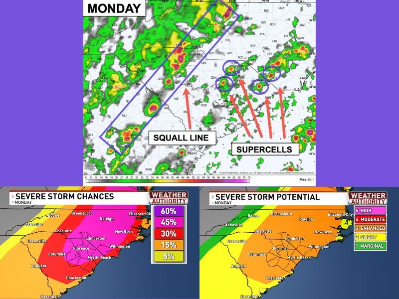
Forecasters say the first round of storms Monday may begin with individual rotating supercells developing from late morning into mid-afternoon. These isolated storms are capable of producing the most intense severe weather, including strong tornadoes if the atmosphere becomes sufficiently unstable.
Communities across Florence, Lumberton and surrounding areas of the Pee Dee and Border Belt regions may fall within the corridor where these storms could initially develop. Meteorologists say sunshine during the morning hours could significantly increase storm intensity by adding more atmospheric energy.
Squall Line Expected to Sweep Across the Carolinas Later
After the initial supercell phase, a powerful squall line is expected to develop along the advancing cold front later in the afternoon. This line of storms is expected to move quickly across South Carolina and into central North Carolina, bringing the potential for damaging straight-line winds and additional tornadoes.
Cities including Columbia, Charleston, Charlotte and Raleigh could experience severe thunderstorms as the line moves through the region. Even storms that do not produce tornadoes may still generate strong wind gusts capable of causing damage and power outages.
Storm Risk Highest Across Pee Dee and Border Belt Regions
Forecast maps highlight a corridor stretching from Florence, Myrtle Beach and Lumberton toward central North Carolina where severe storm probabilities are highest.
This area sits within the zone where meteorologists expect the strongest combination of wind shear, instability and storm development. While severe weather is not guaranteed for every community, experts stress that the atmosphere appears capable of producing significant storms if conditions align properly.
Forecast Still Depends on Key Atmospheric Factors
Meteorologists emphasize that several factors could still influence the final severity of the event. Cloud cover Monday morning could reduce available storm energy, potentially lowering storm intensity. Additionally, if the cold front moves through faster than expected, the severe threat could decrease. However, forecasters say those scenarios appear less likely than earlier projections, and the region should remain prepared for the possibility of severe storms.
Officials urge residents to stay weather-aware Monday and ensure they have multiple ways to receive warnings if storms develop. Stay with NapervilleLocal.com for continuing coverage and updates as meteorologists track this developing severe weather threat across the Carolinas.

I’ve lived in Naperville long enough to see how quickly our community changes — from new developments downtown to sudden shifts in our Midwest weather. Reporting on Naperville news and daily forecasts gives me the chance to keep neighbors informed about what really matters. My goal is simple: deliver clear, timely updates so you always know what’s happening in our city and what to expect from the skies above.