
Carolinas, Tennessee and North Georgia Braced for Short-Range NAM Snow Event as 2–5 Inches Target Southern Appalachians Saturday
SOUTHEASTERN UNITED STATES — A short-range winter weather threat is rapidly coming into focus across parts of the Southeast as the latest NAM model guidance locks in a narrow but impactful snow band stretching from eastern Tennessee into the Carolinas and north Georgia by Saturday.
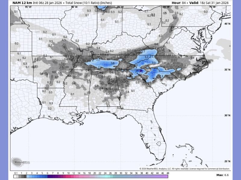
The newly released short-range NAM run shows accumulating snow developing within the next 84 hours, shifting this setup firmly out of long-range speculation and into an actionable forecast window. The data highlights a corridor of heavier snowfall across the higher elevations of the southern Appalachians, with surrounding areas seeing lighter but still disruptive totals.
Where the Snow Is Most Likely to Accumulate
According to the NAM snowfall output, the highest totals are expected across portions of eastern Tennessee, western North Carolina, upstate South Carolina and north Georgia. Several mountain zones fall within a 2–5 inch snowfall range, with localized pockets possibly exceeding those amounts where banding intensifies.
Lower elevations outside the mountains are expected to see lighter accumulations or a mix of snow and rain, but even minor snowfall in this region can quickly impact travel and daily routines.
Timing and Short-Range Confidence
The NAM model places the core of this snow event during the overnight hours into Saturday morning, a timing that favors accumulation due to colder surface temperatures. Unlike earlier long-range projections, this run represents short-range guidance, significantly increasing forecast confidence.
Forecasters note that once models reach this timeframe, dramatic shifts become less likely, meaning snow totals may still adjust slightly but the overall setup is unlikely to disappear.
Why This Event Matters for the Southeast
Snow events of this scale are relatively uncommon across much of the Southeast, especially outside the higher terrain. Even modest snowfall can lead to hazardous road conditions, school closures and disruptions to normal activity.
The data shows the Gulf Coast largely remaining dry and snow-free, while the focus remains locked on inland areas north of the coastal plain. This sharp gradient highlights how narrowly focused the system is, increasing the importance of precise location tracking.
What Residents Should Prepare For
Residents in the Carolinas, eastern Tennessee and north Georgia should be prepared for slick roads, delayed travel and possible local closures Saturday morning. Mountain communities, in particular, may experience the most significant impacts if snow bands persist longer than expected.
As this system transitions from forecast discussion to near-term reality, additional short-range updates will refine snowfall totals and pinpoint exact impact zones.
For continued coverage of major weather developments affecting the region and beyond, stay with NapervilleLocal.com for clear, data-driven updates.

I’ve lived in Naperville long enough to see how quickly our community changes — from new developments downtown to sudden shifts in our Midwest weather. Reporting on Naperville news and daily forecasts gives me the chance to keep neighbors informed about what really matters. My goal is simple: deliver clear, timely updates so you always know what’s happening in our city and what to expect from the skies above.