
Central Alabama Weather Update: Heaviest Rain Shifts South of I-20 as North Counties Expect Lighter Showers and Cooler Tuesday
BIRMINGHAM, ALABAMA — A steady wave of rain moved through Alabama late Monday night, but meteorologists say the heaviest rainfall has shifted south of Interstate 20, sparing much of central and northern Alabama from significant accumulation.
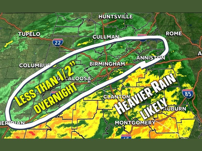
As of 9:45 p.m. Monday, radar from WTM 13 First Warning Weather showed that the most intense rain bands had pushed toward southern counties, while areas including Tuscaloosa, Jefferson, Shelby, St. Clair, Blount, Cullman, Calhoun, and Etowah were only seeing light to moderate showers.
Heaviest Rain Stays South, Light Showers Fill In
Forecasters said the gap between two heavier rain bands has started filling in with a lighter, steady rain, but overall rainfall totals in most north-central counties will remain modest.
“We’re expecting less than half an inch of rain overnight for most of central Alabama,” meteorologists said. “It’s not going to be enough to cause any major issues on the roads.”
The heaviest rainfall totals are expected further south — in areas around Montgomery, Clanton, and Auburn — where radar indicates stronger and more widespread rain bands continuing overnight.
No Travel Hazards, But Cooler Weather Coming
Meteorologists emphasize that there is no danger to travel, as conditions are expected to remain stable with wet roads but no flooding or ice risk.
“We’ll dry out long before it gets cold enough for that,” forecasters assured.
By early Tuesday, most of the precipitation will have exited the region, leaving behind damp roadways and cooler air. Temperatures will begin to fall steadily through the day, with highs struggling to reach the mid-40s to low-50s across much of northern Alabama.
Tuesday’s Forecast: Cold Air Takes Over
While the rain will move out by sunrise, the main story for Tuesday will be the sharp temperature drop that follows. Gusty northwest winds will usher in colder air across Cullman, Anniston, and Gadsden, making it feel significantly chillier than recent days.
Forecasters expect overnight lows Tuesday into Wednesday to dip near freezing in northern counties, though no additional precipitation is expected.
Outlook for Midweek
The midweek outlook shows dry but cold weather, with partly cloudy skies and a gradual warming trend beginning late Wednesday. Another rain system may develop toward the weekend, but forecasters say it’s too early to determine timing or intensity.
For now, the immediate forecast remains calm — just light overnight rain, clearing skies by morning, and a cold start to Tuesday.
Stay updated on local weather alerts and forecasts through NapervilleLocal.com.

I’ve lived in Naperville long enough to see how quickly our community changes — from new developments downtown to sudden shifts in our Midwest weather. Reporting on Naperville news and daily forecasts gives me the chance to keep neighbors informed about what really matters. My goal is simple: deliver clear, timely updates so you always know what’s happening in our city and what to expect from the skies above.