
Central and North Texas Reveal Storm’s Frozen Footprint as Satellite Shows Snow, Sleet, and Ice Swath From Austin to DFW
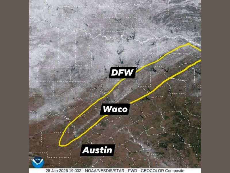
TEXAS — A newly analyzed visible satellite image captured Wednesday confirms the extent of frozen precipitation left behind by a recent winter storm across Central and North Texas, clearly outlining where snow, sleet, and ice accumulated on the ground.
In the image, widespread white shading stretches across much of North Texas, marking areas where frozen precipitation remained visible from space. Farther south, a distinct narrow band of heavier sleet is clearly identifiable, tracing the path of the storm that moved through the region over the weekend.
Tracking the Thundersleet Storm’s Path
The storm responsible for this frozen swath produced an unusual thundersleet event on Saturday, traveling from Lampasas through Gatesville, Valley Mills, and Hillsboro. The satellite image highlights this path with a clearly defined stripe of heavier sleet accumulation.
This corridor runs through Austin, northward past Waco, and into the Dallas–Fort Worth (DFW) area. The sharp contrast between white-covered ground to the north and darker, less affected areas to the south underscores how localized and intense the sleet band was.
What the White Areas on the Satellite Image Mean
In visible satellite imagery, white ground coloration outside of cloud cover indicates snow, sleet, or ice remaining on the surface. Over North Texas, the broader white coverage shows where colder air allowed frozen precipitation to persist.
The narrower, elongated band farther south represents where heavier sleet fell, even though surrounding areas may have seen less accumulation. This confirms that the storm’s most intense frozen precipitation was tightly focused rather than widespread.
Why This View Matters
Seeing frozen precipitation from above offers a rare and valuable perspective. While radar shows what falls from the sky, satellite imagery reveals what actually stuck, providing insight into how surface temperatures and precipitation types varied across short distances.
The visibility of this sleet swath days later highlights how impactful the storm was, even without a classic snowstorm setup. Events like this are uncommon in Texas and demonstrate how winter storms in the region can behave very differently from those in colder climates.
A Reminder of Texas Winter Variability
This satellite-confirmed footprint serves as a reminder that Texas winter weather can produce highly localized but significant impacts. A narrow band of sleet can cause travel hazards, power issues, and long-lasting ground ice, even when nearby areas see minimal effects.
As winter systems continue to affect different parts of the country, this event stands out as a clear example of how thundersleet and sleet-dominant storms can leave lasting marks across Central and North Texas.
For continued coverage of notable weather events and the science behind them, visit NapervilleLocal.com for the latest updates.

I’ve lived in Naperville long enough to see how quickly our community changes — from new developments downtown to sudden shifts in our Midwest weather. Reporting on Naperville news and daily forecasts gives me the chance to keep neighbors informed about what really matters. My goal is simple: deliver clear, timely updates so you always know what’s happening in our city and what to expect from the skies above.