
Central and Southern Indiana Under ‘All Hazards’ Severe Weather Threat Thursday Afternoon With Damaging Winds and Isolated Tornado Risk
INDIANA — An “all hazards” severe weather risk is setting up for Thursday afternoon and evening, with the greatest concern focused across central and southern parts of the state, especially along and south of the I-70 corridor.
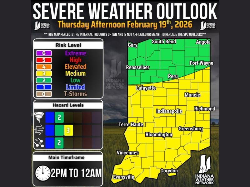
Forecasters indicate the environment could support damaging wind gusts up to 60 mph, a couple of tornadoes, and isolated hail up to quarter size, particularly during peak heating hours later in the day.
Timing: 2 PM Through Late Evening
The primary window for severe weather is expected from 2:00 PM ET through 11:59 PM ET Thursday, February 19, 2026.
Storms are forecast to move from southwest to northeast at 40 to 50 mph, meaning once storms develop, they could impact communities quickly. Fast storm motion may reduce rainfall totals in some areas but increases the potential for wind damage.
Areas With the Highest Risk
The greatest severe threat is expected across central and southern Indiana, including Indianapolis, Bloomington, Terre Haute, Evansville, Vincennes, Corydon, Greensburg, Richmond, and Muncie.
These areas fall within a Level 2 (Slight) risk, meaning scattered severe storms are possible and some could become strong. Northern Indiana communities such as South Bend, Gary, Fort Wayne, Angola, Rensselaer, and Peru remain under a lower, more isolated risk (Level 1/Marginal). Severe storms are still possible there, but coverage should be more limited.
Primary Threats Ranked
Forecasters outline the hazards in this order: damaging winds up to 60 mph, a couple of tornadoes possible, and isolated hail around one inch in diameter. Wind is expected to be the most widespread threat. Gusts near 60 mph can down tree limbs, cause scattered power outages, and create hazardous driving conditions.
The tornado threat, while not widespread, is supported by a highly sheared environment — meaning strong wind energy in the atmosphere could allow some storms to rotate. Only one well-organized storm is needed to produce a tornado. Hail is expected to be more isolated but could reach quarter size in the strongest storms.
Why the Setup Is Concerning
While instability — the fuel storms rely on — is not overly abundant, there appears to be enough combined with strong wind shear to support severe weather development.
The best overlap of ingredients is expected along and south of the I-70 corridor, which is why central and southern Indiana are highlighted for the greatest concern. Not every community will see severe weather, but any storm that intensifies could briefly become dangerous.
Stay Weather Aware Thursday Afternoon
With storms moving quickly, warnings could be issued with limited lead time. Residents should ensure weather alerts are enabled on mobile devices, identify a safe shelter location in advance, and secure loose outdoor items before storms arrive. This does not appear to be a statewide outbreak scenario, but localized severe impacts are possible, especially during the late afternoon and evening hours Thursday.
For continued updates and real-time weather coverage, stay connected with NapervilleLocal.com and share how conditions are impacting your area in the comments so others can stay informed.

Naperville is a community with stories that deserve to be told — both the serious ones about safety and justice, and the lighter ones that capture our culture and daily life. I focus on covering crime reports and court updates while also highlighting the traditions, events, and social trends that shape who we are. Through my reporting, I want to give readers a fuller picture of Naperville — the challenges we face and the character that keeps our city strong.