
Central Florida and Tampa Bay Face First-Ever Extreme Cold Watch as Wind Chills Drop to Single Digits
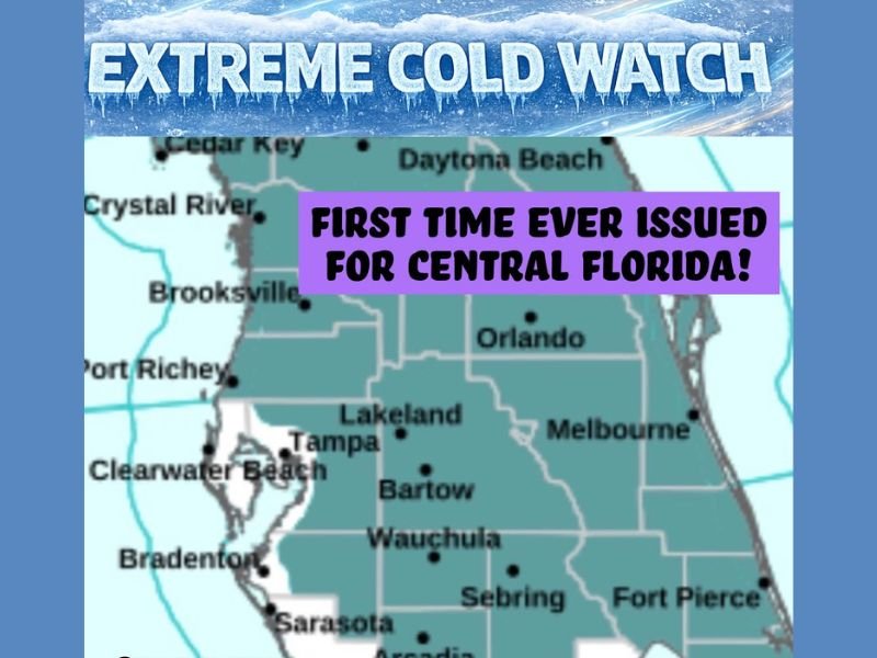
FLORIDA — A first-ever Extreme Cold Watch has been issued for Central Florida and the Tampa Bay area east of Interstate 75, marking an exceptionally rare cold-weather alert for the region as Arctic air surges south this weekend.
According to the alert, wind chill values could drop as low as 8°F, while overnight low temperatures may fall to around 20°F, creating hard freeze conditions from Saturday night into Sunday morning.
Why This Extreme Cold Watch Is Historically Significant
The National Weather Service notes that this type of alert was previously known as a Wind Chill Watch or Warning and has not been issued for this region since 2010. The upgrade to an Extreme Cold Watch reflects both the intensity and rarity of the incoming cold air mass.
For Central Florida, where prolonged freezes are uncommon, this level of cold poses unusual risks to people, pets, pipes, and agriculture.
Areas Impacted by the Cold Watch
The Extreme Cold Watch covers much of Central Florida, including:
- The Tampa Bay area
- Communities east of I-75
- Inland portions more vulnerable to radiational cooling
Coastal locations may see slightly higher temperatures, but strong winds are expected to drive wind chills dangerously low across the region.
What Residents Should Prepare For
Forecast impacts include:
- Wind chills as low as 8°F
- Hard freeze conditions with lows near 20°F
- Increased risk of frostbite with prolonged exposure
- Potential damage to sensitive plants, plumbing, and unprotected infrastructure
Residents are urged to protect pipes, insulate exposed plumbing, bring pets indoors, and limit time outside during the coldest overnight hours.
Bottom Line
This is not a typical Florida cold snap. The issuance of a first-ever Extreme Cold Watch underscores the seriousness of the situation, with dangerously low wind chills and hard freeze conditions expected overnight.
Officials warn that conditions could worsen if winds remain elevated, and the watch may be upgraded as confidence increases. Residents should take immediate precautions and stay alert for updates. For continued coverage of significant weather events impacting communities across the country, stay with NapervilleLocal.com.

I’ve lived in Naperville long enough to see how quickly our community changes — from new developments downtown to sudden shifts in our Midwest weather. Reporting on Naperville news and daily forecasts gives me the chance to keep neighbors informed about what really matters. My goal is simple: deliver clear, timely updates so you always know what’s happening in our city and what to expect from the skies above.