
Central North Carolina Snow Chances Narrow as Rain Dominates, With Brief Slushy Surprise Possible in a Thin Sunday Window
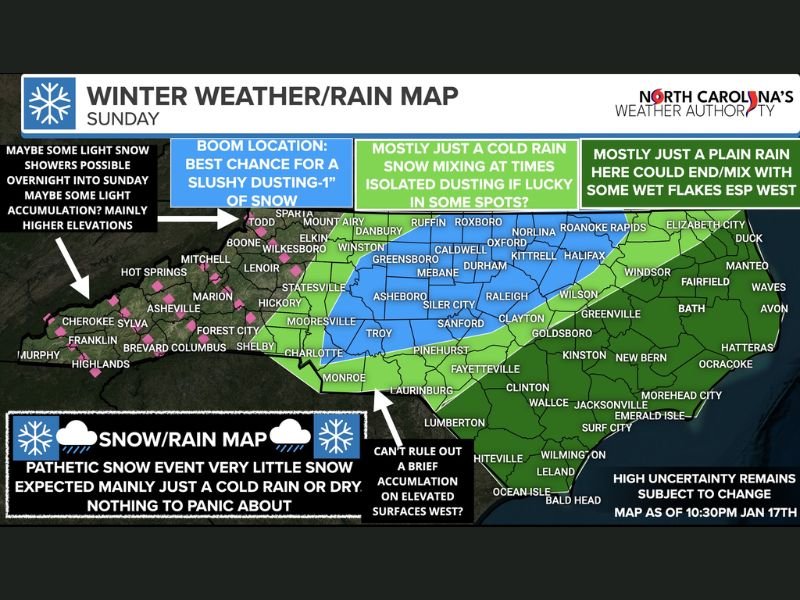
NORTH CAROLINA — A complicated late-week winter setup is unfolding across the state, and while widespread snowfall is not expected, a narrow window exists where parts of Central North Carolina could briefly flip from rain to snow on Sunday, producing a quick dusting to around one inch in isolated spots before conditions deteriorate again.
Forecasters describe this system as high-uncertainty and highly timing-dependent, with the outcome hinging on how quickly colder air can catch up to departing moisture.
Forecast Confidence Remains Low as System Enters Nowcasting Phase
Meteorologists stress that this forecast is now in the nowcasting stage, meaning small changes in temperature, moisture depth, or timing could completely alter results.
Earlier model runs struggled with the setup, but newer guidance suggests a narrow overlap period where cold air arrives just as lingering precipitation exits — a classic scenario for brief, low-impact snow bursts.
Rain Arrives First, With a Late Changeover Possible Sunday
Moisture moves in overnight into early Sunday, starting as cold rain across most of the state. As the system evolves:
- Late morning into early afternoon Sunday is the most favorable window for any snow
- Colder air arrives from the northwest as precipitation pulls east
- Where timing aligns, rain may briefly change to snow
This overlap is expected to be short-lived, limiting accumulation potential.
Central North Carolina Holds the Best Chance for a Slushy Dusting
The highest chance for minor accumulation is centered across parts of Central North Carolina, roughly from Greensboro through the Triangle toward Charlotte’s northern suburbs.
In this zone:
- Dynamic cooling may briefly enhance snowfall
- Dusting to 1 inch is possible on grassy or elevated surfaces
- A few isolated locations could approach 2 inches, but this would be the upper ceiling
Even here, many locations may see flakes with little or no accumulation.
Eastern and Coastal Areas Expected to Stay Mostly Rain
Across Eastern and Coastal North Carolina, the forecast strongly favors:
- Cold plain rain
- Minimal cold air penetration
- Only occasional wet snowflakes mixing in late, if at all
No meaningful accumulation is expected in these areas.
Foothills and Mountains May See Light Overnight Snow Showers
Further west, into the foothills and higher elevations, some light snow showers are possible overnight into Sunday morning.
- Minor accumulation possible at higher elevations
- Impacts expected to remain minimal
- Snow intensity generally light
Road Impacts Limited, But Watch for Evening Black Ice
Because most precipitation falls during daylight and temperatures remain marginal:
- Road impacts should be limited
- Accumulation favors grassy and elevated surfaces
However, wet roads that remain damp after sunset Sunday could refreeze, leading to isolated black ice, especially in colder inland areas.
Bottom Line: Mostly Rain, With a Narrow Snow Window for a Few
This system is not a major winter storm, but it is tricky, and small changes could shift outcomes locally. Most areas will see cold rain, some will see flakes with little impact, and a narrow corridor in Central North Carolina could experience a brief slushy surprise before conditions improve.
More refinements are expected as updated data comes in. If you live in the potential transition zone, monitor updates closely through Sunday morning, as last-minute adjustments are likely.
For continuing weather updates, regional breakdowns, and developing forecasts, stay connected with NapervilleLocal.com and share what you’re seeing where you live.

I’ve lived in Naperville long enough to see how quickly our community changes — from new developments downtown to sudden shifts in our Midwest weather. Reporting on Naperville news and daily forecasts gives me the chance to keep neighbors informed about what really matters. My goal is simple: deliver clear, timely updates so you always know what’s happening in our city and what to expect from the skies above.