
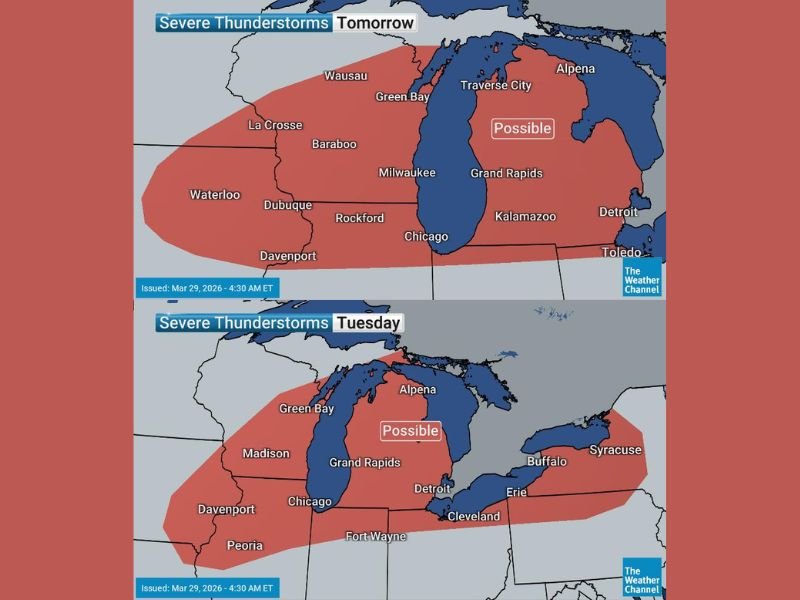
Chicago, Milwaukee, Green Bay, Grand Rapids, Detroit, Cleveland, Buffalo Face Monday Night Through Tuesday Severe Thunderstorm Risk Across Great Lakes
UNITED STATES — A developing spring weather pattern is set to bring severe thunderstorm risks across the Great Lakes region from Monday night into Tuesday, with major cities from Illinois to New York in the potential impact zone.
Forecast data shows storms beginning around sunset Monday and continuing through Tuesday, marking the start of a more active and potentially volatile stretch of weather heading toward Easter.
Monday Night Storms Begin Near Chicago and Milwaukee
The first round of thunderstorms is expected to develop Monday evening, particularly across:
- Chicago, Illinois
- Milwaukee, Wisconsin
- Rockford, Illinois
- Davenport, Iowa
- La Crosse, Wisconsin
Storms are likely to flare up near or after sunset, fueled by increasing moisture and instability moving into the region. These storms may strengthen as they track eastward overnight toward Lake Michigan.
Tuesday Expands Risk Across Michigan and Ohio Valley
By Tuesday, the threat zone shifts and expands deeper into the Great Lakes and eastern regions, including:
- Green Bay, Wisconsin
- Grand Rapids, Michigan
- Detroit, Michigan
- Fort Wayne, Indiana
- Cleveland, Ohio
- Erie, Pennsylvania
- Buffalo, New York
- Syracuse, New York
The forecast highlights a broad area marked as “possible” for severe storms, indicating conditions supportive of stronger thunderstorm development.
What Makes This Setup Important
Meteorologists are pointing to this system as the beginning of a larger pattern shift, where:
- Storm chances increase nearly every day across parts of the U.S.
- Moisture from the south feeds into the Plains and Eastern states
- Multiple rounds of storms become possible through the week
This is not expected to be a one-day event but rather the first in a series of storm systems.
Potential Threats From These Storms
While exact severity will depend on how the atmosphere evolves, early indicators suggest:
- Gusty and potentially damaging winds
- Frequent lightning
- Heavy downpours
- Isolated stronger storms cannot be ruled out
Confidence in exact timing and intensity is still developing, but the setup supports at least low to moderate severe potential.
Timing Breakdown Residents Should Watch
- Monday Evening/Night: Storms begin in western Great Lakes (Illinois, Wisconsin)
- Overnight: Activity pushes east toward Michigan
- Tuesday: Storms expand across Michigan, Ohio, and into Pennsylvania and New York
Residents should be prepared for changing conditions during both nighttime and daytime hours, especially commuters and overnight travelers.
A Busy Spring Pattern Ahead
This system signals a broader transition into a more active spring weather regime, with:
- Repeated storm chances through the week
- Increasing instability across the central and eastern U.S.
- Continued monitoring needed for stronger severe setups
Communities across the Great Lakes should stay alert as this evolving pattern could bring multiple rounds of impactful weather. Stay with NapervilleLocal.com for continuing updates as timing and severity details become clearer heading into Monday night and Tuesday.

I’ve lived in Naperville long enough to see how quickly our community changes — from new developments downtown to sudden shifts in our Midwest weather. Reporting on Naperville news and daily forecasts gives me the chance to keep neighbors informed about what really matters. My goal is simple: deliver clear, timely updates so you always know what’s happening in our city and what to expect from the skies above.