
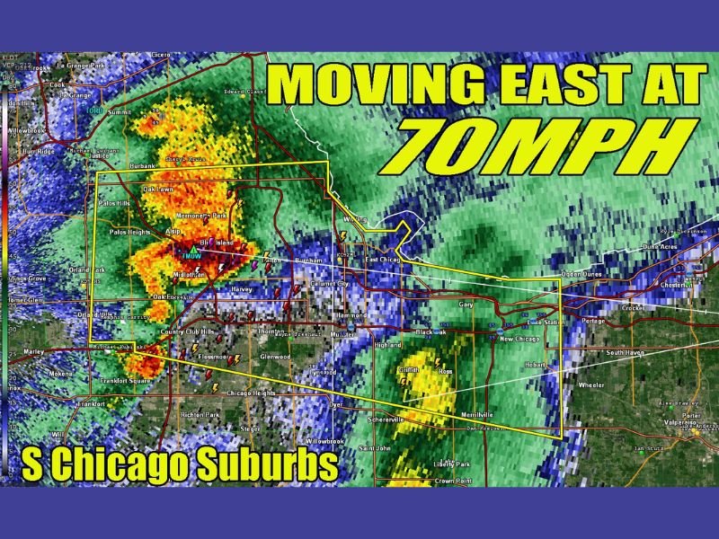
Chicago South Side Severe Storm With Quarter Size Hail Races From Oak Lawn Midlothian Toward Gary Indiana at 70 MPH
CHICAGO, ILLINOIS — A fast-moving severe thunderstorm is racing across the south side of Chicago and into northwest Indiana, bringing quarter-size hail, intense lightning, and heavy rain. The storm is moving east at nearly 70 mph, making it one of the fastest-moving systems of the evening.
Storm Intensifies Over South Chicago Suburbs
The strongest part of the storm developed across communities including Oak Lawn, Burbank, Alsip, and Midlothian, where radar shows intense reflectivity and frequent lightning strikes.
Areas around Blue Island and Merrionette Park are also seeing the core of the storm, with heavy rainfall and hail reported within the warning zone.
Rapid Movement Toward Indiana
The storm is quickly pushing east, crossing through Calumet City and moving toward Hammond and Gary, Indiana. Given its speed, conditions are changing rapidly, leaving little time for preparation once the storm approaches.
Communities in northwest Indiana, including Hammond, Highland, and Griffith, are next in line to experience the strongest impacts.
Quarter Size Hail and Strong Winds Possible
This storm has been flagged for producing hail up to quarter size, along with strong wind gusts. The combination of hail and high winds could lead to minor damage, especially to vehicles, roofs, and outdoor objects.
Frequent lightning is also being observed, increasing the risk for dangerous outdoor conditions.
Fast Moving Storm Raises Immediate Safety Concerns
With forward motion near 70 mph, this storm is moving faster than typical traffic speeds in the region. This rapid pace means warnings may have very short lead times, emphasizing the need for immediate action when alerts are issued.
Travel conditions along major roadways could deteriorate quickly due to heavy rain and reduced visibility.
What Residents Should Expect Next
Residents across the south Chicago suburbs and into northwest Indiana should remain alert as this storm continues moving east. Conditions can worsen rapidly, especially in areas directly in the storm’s path.
Additional storms may follow behind, maintaining an active and potentially hazardous evening across the region. Stay with NapervilleLocal.com for real-time updates, radar tracking, and severe weather alerts as this fast-moving storm continues across Illinois and Indiana.

I’ve lived in Naperville long enough to see how quickly our community changes — from new developments downtown to sudden shifts in our Midwest weather. Reporting on Naperville news and daily forecasts gives me the chance to keep neighbors informed about what really matters. My goal is simple: deliver clear, timely updates so you always know what’s happening in our city and what to expect from the skies above.