
Chicago’s Long Warm Spell Begins Today: 80°F Within Reach by 3 PM Before Showers and Thunderstorms Move In With Up to Half an Inch of Rain
CHICAGO, Ill. — Sunday is kicking off what promises to be a long-lasting warm spell across the Chicago area, with temperatures surging toward 80°F by mid-afternoon as strong warm air advection pushes northward from the Gulf states.
But the warmth comes with a catch — showers and thunderstorms are expected to approach from the southwest around 3 PM, bringing roughly half an inch of rainfall with locally higher amounts possible in stronger storms. Dew points are also on the rise, adding a noticeably more humid feel to the air as the day progresses.
80°F Within Reach by 3 PM — A Long Warm Spell Begins
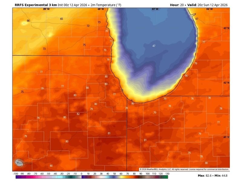
The temperature map tells a dramatic story for Sunday afternoon. A powerful surge of warm air is streaming northward from the Gulf states, pushing readings across the broader Chicago region well into the upper 70s and touching 80°F by around 3 PM. Communities to the south and west of the city are already sitting in the low 80s, with the warmth advancing steadily northward through the morning and early afternoon hours.
This is not a one-day warm-up — forecasters are describing today as the opening chapter of a long-lasting warm spell for the area, meaning the heat building in today will stick around for an extended stretch of days ahead.
Windy Conditions as Gulf Moisture Streams North
Along with the warmth, wind will be a notable feature of the day. Strong warm air advection is driving the temperature surge, and that same atmospheric flow is producing breezy and at times gusty conditions across the Chicago metro and surrounding communities.
Dew points are climbing alongside temperatures, meaning the air will carry a noticeably more humid feel compared to recent days — another clear signal that a Gulf-influenced airmass has firmly taken control of the region’s weather pattern heading into the week ahead.
Dry Until 3 PM — Then Showers and Thunderstorms Arrive
The morning and early afternoon will remain completely dry, giving residents a solid window to enjoy the unseasonably warm temperatures before the weather turns. However, showers and thunderstorms approaching from the southwest are expected to reach the Chicago area by approximately 3 PM, ending the dry stretch and bringing a more active end to the day.
The rainfall associated with this system is forecast at around half an inch for most locations, with locally higher amounts possible where stronger thunderstorm cells develop. The precipitation map shows a broad swath of 0.25 to 0.90 inch totals spreading across the region, with some pockets approaching and potentially exceeding an inch in the heaviest thunderstorm cores.
Residents with outdoor afternoon plans should keep a close eye on the timing of storm arrival and be ready to move activities indoors as the 3 PM window approaches. Stay with NapervilleLocal.com for the latest weather updates and local forecast coverage.

I’ve lived in Naperville long enough to see how quickly our community changes — from new developments downtown to sudden shifts in our Midwest weather. Reporting on Naperville news and daily forecasts gives me the chance to keep neighbors informed about what really matters. My goal is simple: deliver clear, timely updates so you always know what’s happening in our city and what to expect from the skies above.