
Coastal Carolinas Bracing for Potentially Significant Snowstorm as Models Show Sharp Differences and Heavy Snow Bands
NORTH CAROLINA & SOUTH CAROLINA — Confidence continues to increase that a memorable and potentially high-impact winter storm could affect parts of the coastal Carolinas, even as forecast models show major differences in where the heaviest snow may ultimately fall.
Meteorologists caution that this developing system will be working with tremendous atmospheric energy, creating sharp contrasts between areas that see heavy snowfall and nearby locations that receive much less. At this stage, pinpointing exact snow totals remains difficult, but the overall risk is becoming clearer.
Forecast Models Highlight High Snow Potential — With Major Variability
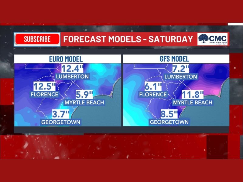
Side-by-side comparisons of leading forecast models show notable differences in snowfall placement, underscoring why specific totals are still uncertain.
The European (EURO) model depicts:
- Lumberton, NC: around 12.4 inches
- Florence, SC: near 12.5 inches
- Myrtle Beach, SC: roughly 5.9 inches
- Georgetown, SC: around 3.7 inches
The GFS model, meanwhile, shifts the heavier snow band eastward:
- Lumberton, NC: about 7.2 inches
- Florence, SC: near 6.1 inches
- Myrtle Beach, SC: as high as 11.8 inches
- Georgetown, SC: roughly 8.5 inches
These differences illustrate how small changes in storm structure could dramatically alter local outcomes.
Why Confidence Is Rising Despite Uncertainty
While snow totals have shifted significantly from update to update — and are expected to continue doing so — meteorologists stress that the overall signal for a high-impact winter storm remains intact. The presence of strong energy in the atmosphere increases the likelihood of intense snow bands, which often lead to sharp gradients in accumulation.
Forecasters note that six hours ago, model projections looked different, and six hours from now they will likely change again. This volatility is typical of dynamic winter systems approaching the refinement stage.
Travel Impacts Becoming a Growing Concern
Even without finalized snowfall amounts, forecasters warn that very difficult travel conditions are increasingly likely as the storm evolves. Heavy snowfall rates, combined with shifting band placement, could lead to rapidly deteriorating road conditions in localized areas.
The region is now entering the phase where meteorologists will gradually narrow down the most likely zones for heavy snow, but residents across coastal North Carolina and South Carolina should be prepared for rapidly changing forecasts.
What Happens Next
Over the next 24 to 48 hours, forecasters expect clearer agreement on where the strongest snow bands will set up. Until then, officials urge residents to monitor updates closely and avoid focusing on any single snowfall number.
One message is already clear: the risk of a significant winter storm across the coastal Carolinas is real and increasing. For continued updates as this forecast sharpens, stay connected with coverage from NapervilleLocal.com.

I’ve lived in Naperville long enough to see how quickly our community changes — from new developments downtown to sudden shifts in our Midwest weather. Reporting on Naperville news and daily forecasts gives me the chance to keep neighbors informed about what really matters. My goal is simple: deliver clear, timely updates so you always know what’s happening in our city and what to expect from the skies above.