
Colorado and Kansas Snow Outlook: Quick-Moving Storm Spreads Mountain Snow West-to-East, Then Brings Light Accumulations to the Plains Tonight
COLORADO — A quick-moving winter system is spreading snow across the Western Slope and pushing west to east across the mountains today, with snow showers expected to develop east of the Continental Divide as the storm shifts onto the plains. By later afternoon and tonight, the same system is forecast to spread areas of light snow across eastern Colorado and into western Kansas, with most accumulation favored in Colorado’s higher terrain.
Meteorologists tracking the setup describe it as a fast, progressive storm that will not linger long in any one spot, but could still create short periods of reduced visibility and slick travel—especially in the mountains and along higher passes.
Where Snow Is Falling First: Western Slope and Mountain Zones
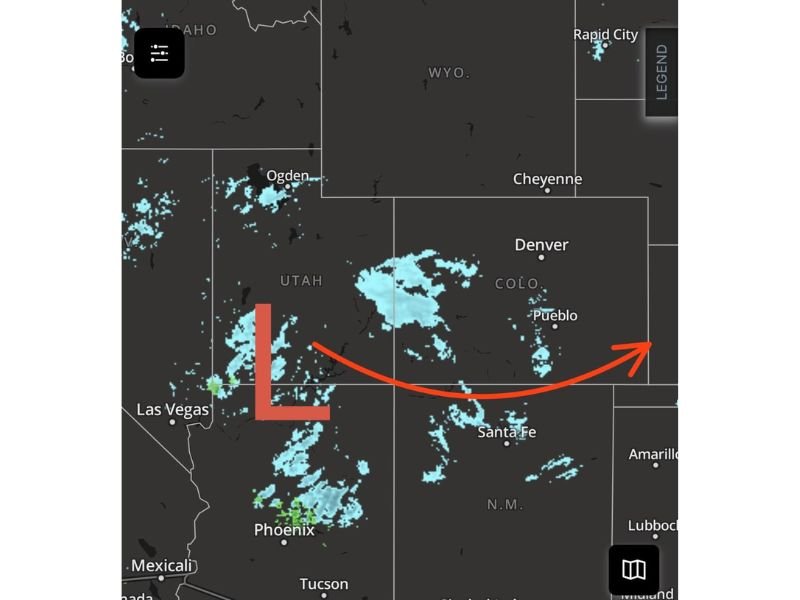
The earliest and steadiest snow focus is expected across Colorado’s Western Slope and into the mountain corridors, where the storm’s lift is strongest. Radar imagery shows the core of the system rotating precipitation across parts of Utah and western Colorado, then gradually spreading eastward into central Colorado.
As the day goes on, snow is expected to move east of the Continental Divide, with scattered snow showers developing on the east side of the mountains. Because the storm is moving quickly, snowfall rates may vary—meaning one location could pick up a quick burst while another nearby town sees lighter, more intermittent snow.
For drivers, the biggest impact window is typically when snow showers intensify briefly and road surfaces cool enough for accumulation, especially at elevation. Even when totals are not extreme, mountain roads can turn slick fast if bursts line up with heavier traffic periods.
What Happens Next: Eastern Plains and Western Kansas Tonight
As the storm advances later this afternoon and into tonight, the snow shield is expected to expand into the eastern plains of Colorado, with light snow also spreading into western Kansas. This is the part of the forecast that often catches people off guard—because plains snow can look light on radar but still create patchy slick spots, especially overnight as temperatures fall.
The expectation with this system is not a widespread heavy snow event for the plains. Instead, the primary story is light snow coverage spreading east behind the storm’s track. Locations in the far eastern plains could see enough accumulation to coat roads and bridges, particularly in areas that get a steadier band instead of quick-hit showers.
Snow Totals: Most Accumulation Stays in the High Terrain
Snowfall probabilities in this forecast keep the emphasis on the mountains and the Western Slope, where the best accumulation potential remains.
Expected accumulation breakdown based on the provided forecast details:
- Western Slope and mountains: Most likely to see the highest totals from this system
- East of the Continental Divide: Generally a trace to 2 inches
- Far eastern plains: Some isolated locations could reach up to 2 inches
- Western Kansas: Mainly light snow, with localized slick travel possible overnight
Because this storm is fast, totals can vary significantly over short distances. A brief, heavier band can quickly add up an inch or two, while other spots may stay closer to a trace if snowfall is more scattered.
What Residents and Travelers Should Watch For
Even a light-accumulation setup can create real travel issues when it hits the wrong time of day or combines with strong bursts of snow. With this storm pushing steadily east, the key impacts will likely be tied to timing and visibility.
Potential issues to plan around include:
- Brief visibility drops during heavier snow showers in the mountains
- Slick passes and higher-elevation roads as snow accumulates faster than crews can treat
- Patchy icy spots on the plains later today and tonight, especially on bridges and overpasses
- Changing road conditions as snow transitions from mountain-focused to plains-focused
The system’s movement also means conditions may improve quickly behind it in some areas, while deteriorating farther east as snow reaches the plains and western Kansas.
As this storm continues sliding east through tonight, the main takeaway is simple: mountain areas and the Western Slope hold the best accumulation potential, while the plains and western Kansas should prepare for lighter snow and localized slick travel.
For more regional weather coverage and developing updates in a clean, reader-first format, keep following NapervilleLocal.com.

I’ve lived in Naperville long enough to see how quickly our community changes — from new developments downtown to sudden shifts in our Midwest weather. Reporting on Naperville news and daily forecasts gives me the chance to keep neighbors informed about what really matters. My goal is simple: deliver clear, timely updates so you always know what’s happening in our city and what to expect from the skies above.