
Colorado and Wyoming Brace for Multi-Day Weather Shift as Weak Showers Give Way to Stronger Tuesday Storm With Rain, Snow and Thunder
COLORADO AND WYOMING — A changing weather pattern is unfolding across the region, beginning with scattered showers through Monday before a stronger and more complex storm system moves in Tuesday, bringing a mix of rain, snow, gusty winds and even isolated thunderstorms.
Forecasters describe the next 48 to 72 hours as active, with conditions shifting notably as the week begins. Sunday and Monday feature a relatively weak disturbance, but Tuesday’s system is expected to pack more punch as it tracks east across the Rockies and High Plains.
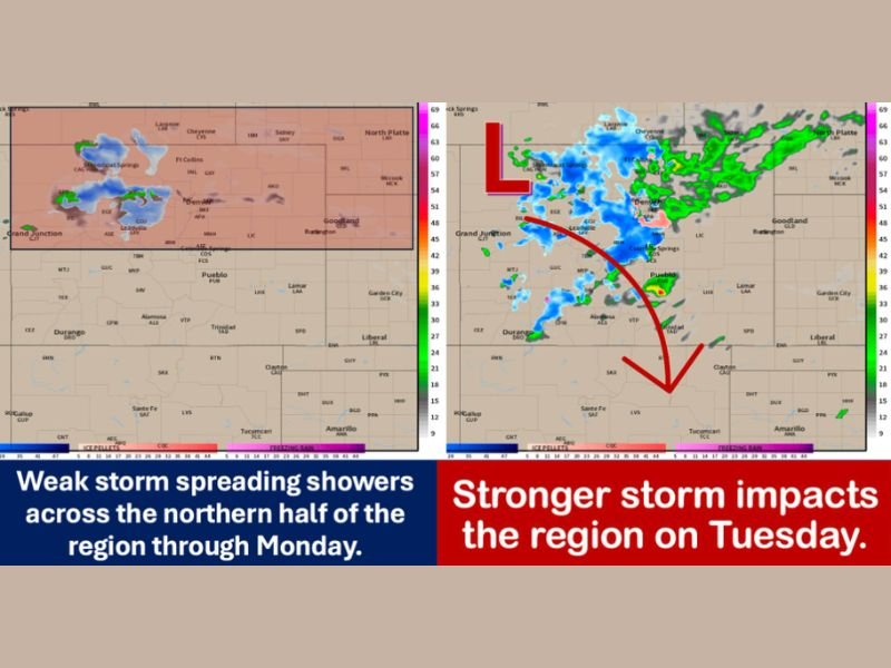
Weak Storm Brings Showers Through Monday
A modest system is spreading rain showers mainly across the northern half of the region, particularly north of the Interstate 70 corridor. Snow is largely confined to higher elevations above 10,000 feet, while a rain-snow mix may dip as low as around 7,000 feet along the Front Range.
Along the I-25 corridor and eastern plains, afternoon highs are expected to reach the 50s and 60s, with a few scattered rain showers and perhaps an isolated thunderstorm. Areas including the Cheyenne Ridge, far northern Colorado, southeast Wyoming, and western Nebraska Panhandle may see brief convective activity.
Farther south into southern Colorado and Kansas, conditions trend drier and warmer. South of Highway 50, temperatures are expected in the 60s to lower 70s, with mid-60s across the western slope Sunday and even warmer readings possible Monday as southwest flow strengthens ahead of the next storm.
Tuesday System Brings Stronger Impacts
Tuesday marks the more significant weather day as a developing low pressure system pivots out of southern Wyoming and tracks west to east across Colorado, Wyoming, and Nebraska.
In the mountains, snowfall and embedded snow squalls are possible as colder air interacts with increasing lift. The western slope may see a combination of rain and snow showers, with isolated thunderstorms possible.
Along the Front Range, I-25 corridor, and eastern plains, lift and instability are expected to increase early Tuesday morning. Rain and snow showers may expand across the northern Front Range, including Larimer and Weld counties, and extend into parts of Wyoming and Nebraska. By late morning through the afternoon, precipitation coverage increases, with a mix that could include rain, snow, small hail, thunder and lightning.
Meteorologists emphasize that microclimates and storm track will play a significant role in determining exact impacts. Some areas may see primarily rain, while nearby elevations could shift between rain and snow in a short time span.
Midweek Break Before Another System
The system is forecast to exit by Wednesday, with conditions turning mostly dry. Early Thursday may begin dry but breezy as another cold front approaches from the northwest. Light showers are possible along the western slope, with additional mountain snow.
Looking ahead to Friday into Saturday, another system may move out of the Four Corners region into the central and northern Plains. Beyond that timeframe, forecast confidence decreases, though the overall pattern appears more active than average.
Residents across Colorado and Wyoming should monitor updates as Tuesday approaches, particularly those in areas prone to rapid weather shifts. For continued regional weather coverage and in-depth updates, visit NapervilleLocal.com for the latest reports.

I’ve lived in Naperville long enough to see how quickly our community changes — from new developments downtown to sudden shifts in our Midwest weather. Reporting on Naperville news and daily forecasts gives me the chance to keep neighbors informed about what really matters. My goal is simple: deliver clear, timely updates so you always know what’s happening in our city and what to expect from the skies above.