
Colorado Issues First-Ever ‘Particularly Dangerous Situation’ Red Flag Warning as 85–105 MPH Winds Threaten Front Range Foothills
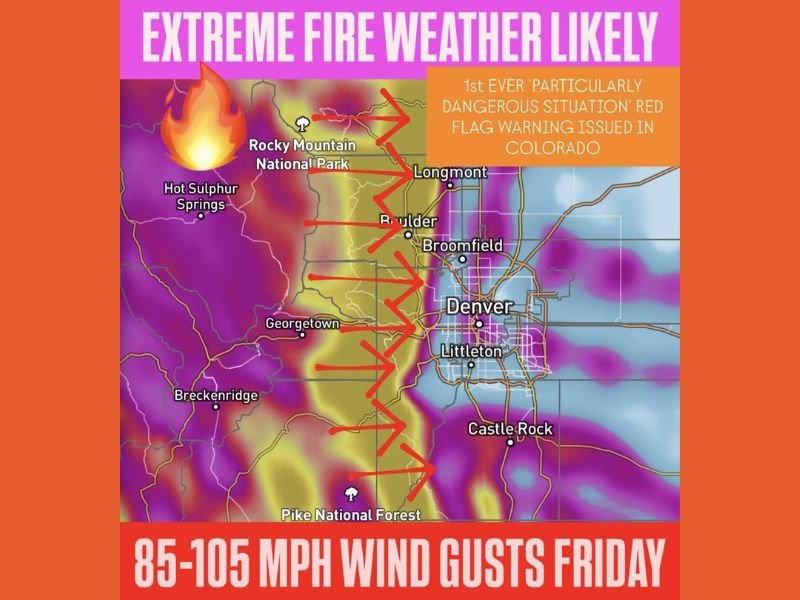
COLORADO — State officials issued the first-ever “Particularly Dangerous Situation” (PDS) Red Flag Warning for parts of Colorado as forecasters warn of explosive wildfire conditions across the Front Range and adjacent eastern foothills. The unprecedented alert, in effect Friday from 5 AM to midnight, highlights a rare combination of extreme winds, critically low humidity, and highly receptive fuel conditions.
Meteorologists report that the corridor stretching from Boulder to Castle Rock could see wind gusts ranging from 85 to 105 miles per hour, with some foothill areas potentially exceeding that threshold. These winds, similar in strength to Category 2 hurricane gusts, create conditions where even a single spark could ignite a fast-moving, uncontrollable fire.
Why This Warning Is Historic
The PDS designation is reserved for only the most extreme wildfire environments — scenarios where the deadliest and most destructive fires typically occur. Colorado has issued Red Flag Warnings many times, but never one classified at this highest level.
Forecasts show a sharp boundary of hot, dry downslope winds descending from the mountains toward densely populated areas, including:
- Boulder
- Broomfield
- Longmont
- Denver metro’s western neighborhoods
- Foothill regions near Georgetown and the Pike National Forest
Humidity is expected to drop into the single digits, making cured grasses and brush highly flammable.
Critical Safety Concerns for Colorado Residents
Emergency officials urge residents to have go bags prepared, review evacuation routes, and ensure pets can be quickly relocated. The speed of potential fire spread under these winds may leave little warning time.
The greatest risk lies along the Front Range foothills, where oxygen-rich wind channels and steep terrain can amplify fire behavior. High-resolution models show a concentrated zone of 85–105 mph gusts between Boulder and Castle Rock, with red shading on fire maps indicating the most vulnerable areas. Even areas east of Denver may experience strong gusts and should remain alert for shifting fire conditions.
Why Illinois Readers Should Track This Event
Wildfires driven by extreme winds in western states can send smoke plumes thousands of miles, sometimes affecting air quality as far east as Illinois. Major fire events also disrupt aviation routes and regional weather patterns.
For updates on national weather emergencies, wildfire impacts, and Midwest safety alerts, follow NapervilleLocal.com for continuous coverage.

I’ve lived in Naperville long enough to see how quickly our community changes — from new developments downtown to sudden shifts in our Midwest weather. Reporting on Naperville news and daily forecasts gives me the chance to keep neighbors informed about what really matters. My goal is simple: deliver clear, timely updates so you always know what’s happening in our city and what to expect from the skies above.