
Colorado Storm System Brings Mountain Snow and I-25 Corridor Rain Into Early Saturday as Snow Levels Drop Near 6,000 Feet
COLORADO — A developing storm system is moving across northern New Mexico into southern Colorado today, spreading a mix of rain and mountain snow from west to east and setting up a changeable Friday night into early Saturday across the Front Range and eastern plains.
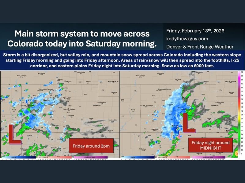
According to the forecast details provided, precipitation began increasing across western Colorado during the morning hours, including areas along the Western Slope. As the system tracks northeast, rain and snow are expected to expand east of the Continental Divide into the foothills, the I-25 corridor, and parts of the eastern plains late Friday into the overnight period.
Storm Track: From New Mexico Into Southern Colorado
The center of the system is forecast to move from northern New Mexico toward southern Colorado through the day. By around mid-afternoon Friday, rain and snow showers were already developing across western and central Colorado, with heavier bands focused over higher terrain.
As the low approaches the Four Corners region and shifts east, precipitation is expected to “blossom” east of the Divide. This includes:
- The foothills west of I-25
- The Palmer Divide
- Communities along and south of Denver
- Teller and El Paso counties
- Portions of the eastern plains overnight
The most organized precipitation appears likely Friday evening into early Saturday morning, with activity tapering off after sunrise Saturday as the system exits.
Mountain Snow Continues, Lower Elevations See Rain — With a Twist
Higher elevations will see continued mountain snow through the event. However, one of the key uncertainties lies in precipitation type for lower elevations.
Forecast guidance suggests snow levels could drop to around 6,000 feet at times. That opens the door for rain mixing with or briefly changing to wet snow in areas such as:
- Teller County
- El Paso County
- The Palmer Divide
- Foothill communities west of I-25
If the storm strengthens more than expected and colder air deepens, snowfall totals could increase in these areas. If it remains weaker, lower elevations may see more scattered rain showers with lighter overall amounts.
Timing: Friday Afternoon Through Early Saturday
The timeline remains one of the most important factors:
- Friday afternoon: Mountain snow and valley rain expand across western and central Colorado.
- Friday evening: Precipitation spreads east of the Divide into foothills and the I-25 corridor.
- Late Friday night into early Saturday: Steadiest precipitation likely, including rain and snow mix in higher foothill communities.
- Saturday morning: Gradual wrap-up as the system pulls away.
Impacts will depend heavily on exact track and temperature profiles. Even small shifts could change snowfall placement and totals.
What Is Certain — And What Isn’t
There are a few things that appear clear:
- There is a storm.
- There will be rain.
- There will be snow in the mountains.
What remains uncertain are snowfall amounts, exact placement of any wet snow in lower elevations, and how quickly colder air settles in overnight. As is often the case with Colorado systems, minor track changes can dramatically alter who sees accumulating snow versus mainly rain.
For now, residents across southern and central Colorado should expect unsettled weather through early Saturday, especially along the I-25 corridor and into foothill communities. For continued regional weather updates and analysis, stay connected with NapervilleLocal.com.

I’ve lived in Naperville long enough to see how quickly our community changes — from new developments downtown to sudden shifts in our Midwest weather. Reporting on Naperville news and daily forecasts gives me the chance to keep neighbors informed about what really matters. My goal is simple: deliver clear, timely updates so you always know what’s happening in our city and what to expect from the skies above.