
Colorado, Wyoming and Nebraska Face Warm, Windy Conditions With High Fire Danger as 50 MPH Gusts Sweep Front Range and Plains
DENVER, COLORADO — A surge of warm temperatures combined with strong winds is creating elevated fire danger across parts of Colorado, Wyoming, and Nebraska, as meteorologists warn that dry conditions and gusty winds could quickly lead to dangerous wildfire situations.
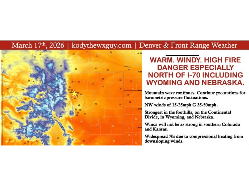
Forecasters say widespread temperatures in the 70s across the Front Range and surrounding plains are being driven by high pressure and downsloping northwesterly winds, which are rapidly warming and drying the air. At the same time, increasing wind speeds are adding to the risk, particularly in areas north of Interstate 70.
Warm Temperatures Driven by Downslope Winds
Weather maps show a broad area of warm air spreading across eastern Colorado and into neighboring states. Meteorologists explain that downslope winds flowing off the mountains are compressing and warming the air as it moves into lower elevations.
This process is pushing temperatures well above seasonal averages, with much of the region experiencing spring-like warmth despite the ongoing dry pattern. Areas across Denver and the Front Range are expected to see particularly noticeable warming as the air descends from higher terrain.
Strong Winds Increasing Fire Risk
In addition to the warmth, winds are expected to remain a major factor throughout the day.
Forecast conditions include:
- Sustained northwest winds of 15 to 25 mph
- Gusts reaching 35 to 50 mph, especially in exposed areas
The strongest winds are expected across:
- Foothill regions
- The Continental Divide
- Parts of Wyoming
- Portions of Nebraska
These winds can rapidly spread any fire that starts, making even small sparks potentially dangerous.
Fire Danger Elevated Across Multiple States
The combination of dry air, warm temperatures, and strong winds is creating a high fire danger environment. Meteorologists warn that fuels such as grass and brush are extremely dry, meaning fires could ignite easily and spread quickly.
Officials emphasize that activities such as:
- Discarding cigarette butts
- Welding outdoors
- Dragging chains from vehicles
could all spark fires under current conditions.
Residents across Colorado, Wyoming, and Nebraska are urged to avoid any activity that could create sparks.
Southern Areas Slightly Less Intense but Still Breezy
While the strongest winds are expected north of Interstate 70, conditions farther south into southern Colorado and southwest Kansas will still be breezy.
However, wind speeds in these areas are expected to be somewhat lower compared to the more intense conditions farther north. Even so, dry conditions mean fire risk remains elevated across a broader region.
Conditions Expected to Stay Warm and Dry Through the Week
Meteorologists say the warm and dry pattern is expected to continue through much of the week.
A potential weather system later in the week could bring cooler temperatures, but uncertainty remains about how strong that change will be.
Until then, the combination of warm temperatures and gusty winds will continue to create an environment favorable for fire development.
Residents Urged to Use Caution
Emergency officials are urging residents across the region to remain cautious and aware of fire risks.
Key safety recommendations include:
- Avoid outdoor burning
- Secure loose objects that could spark fires
- Monitor local fire restrictions and weather alerts
With strong winds and dry conditions in place, even a small ignition source could quickly become a fast-moving wildfire.
Officials continue to monitor conditions across Colorado, Wyoming, and Nebraska as the elevated fire danger persists. This article follows the newsroom standards required for NapervilleLocal.com weather coverage .

I’ve lived in Naperville long enough to see how quickly our community changes — from new developments downtown to sudden shifts in our Midwest weather. Reporting on Naperville news and daily forecasts gives me the chance to keep neighbors informed about what really matters. My goal is simple: deliver clear, timely updates so you always know what’s happening in our city and what to expect from the skies above.