
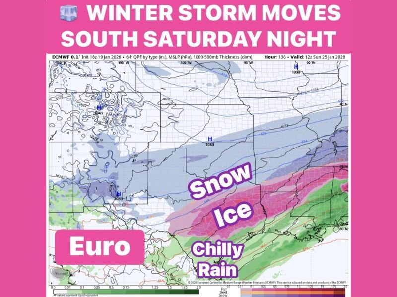
Complex Winter Storm Shifts South Late Saturday, Bringing Snow, Ice, and Freezing Rain From Oklahoma Into Texas
UNITED STATES — A multi-phase winter storm is expected to reorganize and shift south late Saturday night, producing a dangerous mix of snow, freezing rain, sleet, and cold rain across parts of the Southern Plains and Texas as it evolves through the weekend. Forecast guidance shows this system beginning in Oklahoma on Friday before expanding and intensifying as it pushes southward into North, Central, and Southeast Texas.
This setup is concerning because multiple precipitation types will overlap, increasing the risk for travel disruptions, icing, and localized power issues, especially where freezing rain becomes dominant.
Friday: Snow Takes Hold in Oklahoma While North Texas Turns Icy
The storm is expected to start Friday with widespread snow across Oklahoma, where colder air is firmly in place. At the same time, North Texas will see chilly rain develop by evening, which is forecast to transition to freezing rain late Friday night as surface temperatures drop below freezing.
This changeover is critical, as even light freezing rain can quickly coat roads, bridges, and overpasses with ice, making travel hazardous.
Saturday: Freezing Rain and Sleet Expand Southward
By Saturday morning, freezing rain remains a concern across North Texas, while sleet may begin mixing in by afternoon as colder air deepens. The storm system will then continue moving south Saturday night, spreading impacts into Central and Southeast Texas, with conditions worsening closer to the Houston metro area.
This southward push increases the risk for icing in areas that rarely experience winter storms, which can amplify impacts due to limited preparedness and infrastructure resilience.
Late Saturday Night Into Sunday: Snow Returns on the Backside
As the storm pulls east, North Texas is expected to transition back to snow on the backside of the system, particularly late Saturday night into early Sunday. Snow may linger into Sunday morning, while Southeast Texas could continue seeing lingering precipitation into Sunday afternoon before the system finally exits to the east.
Why This Storm Deserves Close Attention
This is not a straightforward snowstorm. The danger lies in the rapid transitions between rain, freezing rain, sleet, and snow, which can change impacts dramatically over short distances.
Key concerns include:
- Freezing rain creating slick roads and ice accumulation
- Tree and power-line stress where icing persists
- Travel becoming dangerous or impossible in affected zones
- Forecast sensitivity, where small temperature shifts can drastically alter outcomes
Bottom Line
A complex and potentially disruptive winter storm will move south late Saturday, bringing snow to Oklahoma, freezing rain and sleet to North Texas, and wintry impacts into Central and Southeast Texas before exiting Sunday. While exact amounts are still being refined, the evolving nature of this system makes it especially hazardous, and residents across the region should closely monitor updates and prepare for rapidly changing conditions.
What are you seeing where you live — snow, ice, or rain? Share your local conditions and stay weather-aware with NapervilleLocal.com as this dynamic winter storm continues to unfold.

I’ve lived in Naperville long enough to see how quickly our community changes — from new developments downtown to sudden shifts in our Midwest weather. Reporting on Naperville news and daily forecasts gives me the chance to keep neighbors informed about what really matters. My goal is simple: deliver clear, timely updates so you always know what’s happening in our city and what to expect from the skies above.