
Confidence Rising for a High-Impact Midwest Winter Storm as Euro Model Signals Snow, Ice, and Sleet from Friday into Saturday
MIDWEST & OHIO VALLEY — Forecast confidence is increasing that a potentially significant winter storm could impact parts of the Midwest and Ohio Valley from Friday into Saturday, according to the latest European (EURO) model guidance. New data suggests the region may be facing a complex, high-impact setup capable of producing heavy snow, major ice accretion, and sleet, depending on the final track and temperature profile.
Meteorologists stress that this is a preparedness window, not a panic moment, but the signal strength is now strong enough that residents should begin planning for possible winter impacts by the end of the week.
Why the EURO Model Has Meteorologists Paying Attention
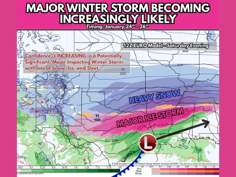
The latest 12z EURO model run shows a well-defined winter system organizing across the central U.S., with cold air entrenched to the north and warmer, moisture-rich air pushing in from the south. This classic collision zone creates a broad swath of winter precipitation types, often associated with high-impact events.
What stands out in this run is:
- Improved model consistency compared to earlier guidance
- Stronger cold air support on the northern side of the system
- A more organized low-pressure track, increasing confidence in impacts
These factors together raise the likelihood that this will not be a minor or nuisance event.
Potential Impacts: Snow North, Ice South, Sleet in Between
If the current setup holds, the storm could produce distinct impact zones across the region:
- Heavy snow on the colder, northern side of the system
- A major ice storm risk closer to the rain-snow transition zone
- Sleet and mixed precipitation in areas where warm air briefly overrides surface cold
Ice accumulation is a particular concern, as even moderate ice can lead to power outages, downed trees, and dangerous travel conditions. This is especially true if winds increase during or after the freezing rain phase.
Timing Window: Friday Into Saturday
Current guidance places the highest impact window between Friday night and Saturday, though some wintry precipitation could begin earlier depending on how quickly the system organizes.
Key timing considerations:
- Friday: Cold air continues pressing south as moisture increases
- Friday night: Wintry precipitation begins developing
- Saturday: Peak impact window for snow, ice, and sleet
Exact timing will be refined as higher-resolution models come into range later this week.
What Is Still Uncertain — And Why It Matters
Despite growing confidence, important details remain unresolved:
- Exact storm track
- Where the rain-to-snow line sets up
- How long freezing rain persists before changing precipitation types
A shift of 50–100 miles in the storm’s path could dramatically alter outcomes for individual communities. That is why forecasters are emphasizing impact awareness rather than exact snowfall or ice totals at this stage.
Preparedness Without Panic
Meteorologists are clear on the message:
Be prepared, not alarmed.
This is the appropriate time to:
- Check winter supplies
- Ensure vehicles are fueled
- Review backup power plans if you rely on electricity for heat
- Stay informed as updates refine impact zones
There is plenty of lead time, and updates over the next several days will clarify who faces the greatest risk.
Bottom Line
A potentially high-impact winter storm is becoming increasingly likely across parts of the Midwest and Ohio Valley late this week. While not all details are locked in, confidence is rising that snow, ice, and sleet could create meaningful disruptions from Friday into Saturday. Forecast clarity will improve with each model cycle, and attention should remain high as this system evolves.
Stay weather-aware and join the conversation by sharing how you’re preparing or what you’re seeing locally at NapervilleLocal.com as this winter threat continues to develop.

I’ve lived in Naperville long enough to see how quickly our community changes — from new developments downtown to sudden shifts in our Midwest weather. Reporting on Naperville news and daily forecasts gives me the chance to keep neighbors informed about what really matters. My goal is simple: deliver clear, timely updates so you always know what’s happening in our city and what to expect from the skies above.