
Critical Fire Danger Erupts Across Oklahoma as Strong Winds and Extremely Dry Air Create Rapid Wildfire Threat Thursday
OKLAHOMA — Critical fire danger is in place Thursday across much of Oklahoma, where a volatile mix of very dry air, strong winds, and parched fuels is creating conditions that could allow any fire to spread rapidly in a short amount of time.
Forecasters warn this is not a routine elevated fire weather day. The combination of low humidity and gusty winds means even a small spark could quickly grow into a dangerous wildfire.
Where the Risk Is Highest
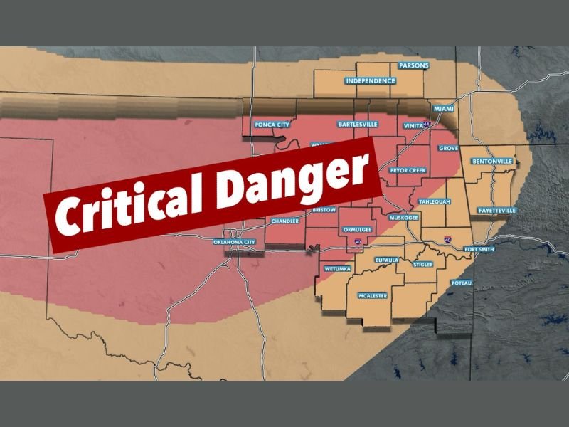
The fire outlook map shows a broad area under critical fire danger, highlighted in red, stretching across central and northeastern portions of the state.
Communities including:
- Oklahoma City
- Ponca City
- Bartlesville
- Pryor Creek
- Muskogee
- Tahlequah
- Okmulgee
- Chandler
are within or near the core of the highest concern zone.
Surrounding areas, including parts of eastern Oklahoma near the Arkansas border — such as Miami, Grove, Bentonville, and Fayetteville — are under elevated to near-critical conditions.
The message from meteorologists is clear: any fire that ignites in these areas could spread quickly and become difficult to control.
Why Conditions Are So Dangerous
Three key ingredients are driving the threat:
- Very Dry Air – Low humidity allows vegetation to ignite more easily and burn more intensely.
- Strong Winds – Gusty conditions can rapidly push flames across open land and spread embers ahead of the main fire.
- Dry Fuels – Grasses and brush are primed to burn, especially after extended dry stretches.
When these factors combine, wildfires can grow rapidly, even from something as small as a dragging trailer chain or improperly extinguished burn pile.
What Officials Are Urging
Residents across affected areas are being asked to:
- Avoid all outdoor burning
- Be cautious with equipment that could spark
- Ensure trailer chains are secured and not dragging
- Avoid parking vehicles on dry grass
- Stay weather aware throughout the day
Officials stress this is not a day to take chances. Fire starts that might normally remain small could escalate quickly under these conditions.
Why This Matters Beyond Oklahoma
While this fire weather setup is centered in Oklahoma, it highlights a broader pattern seen across parts of the central United States during dry, windy stretches in late winter and early spring. Monitoring humidity trends and wind speeds becomes especially important when vegetation is dormant and dry.
Monitoring Continues
Forecasters say they will continue tracking wind speeds and humidity trends throughout the day and provide updates as needed. Conditions could fluctuate depending on how strong winds become and whether humidity drops further than expected.
Residents in Oklahoma should remain alert and prepared for rapid changes if a fire begins nearby. For continued coverage of major weather risks across the United States and how broader weather patterns could eventually impact Illinois, stay connected with NapervilleLocal.com.

Naperville is a community with stories that deserve to be told — both the serious ones about safety and justice, and the lighter ones that capture our culture and daily life. I focus on covering crime reports and court updates while also highlighting the traditions, events, and social trends that shape who we are. Through my reporting, I want to give readers a fuller picture of Naperville — the challenges we face and the character that keeps our city strong.