
Cuba Sees Record-Shocking Freeze: Matanzas Province Station Hits 32°F Near Havana as Arctic Surge Pushes Farther South Than Expected
CUBA — A burst of Arctic air pushed so far south that Cuba recorded a freezing temperature of 32°F, a rare milestone that observers described as unprecedented in recorded history for the location. The report centers on a station in Cubam, located in Matanzas Province east of Havana, where the temperature was documented at the freezing mark—an extraordinary reading for a country known for tropical warmth.
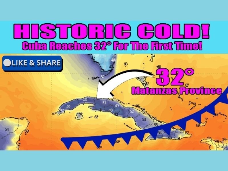
The graphic shared with the provided data calls the event “Historic Cold” and emphasizes that the 32°F reading is being treated as a first-of-its-kind moment in the official record for that station. While brief cold snaps can brush parts of the Caribbean, reaching the freezing point in Cuba is exceptionally uncommon, underlining just how deep and forceful this surge of cold air was.
Where the freezing temperature was recorded
The location referenced in the provided data is Cubam in Matanzas Province, described as being east of Havana. The image highlights the province and points directly toward the area connected to the freeze report, reinforcing that this wasn’t a mountain-top anomaly but a notable low-level temperature outcome in a region that typically stays well above freezing.
The map visualization also shows the presence of a cold front extending across the broader Caribbean region, suggesting a sweeping push of colder air rather than a small, isolated pocket.
Why this Arctic push stands out
The core takeaway is geographic reach. The data frames the event as a sign of how far south the latest surge of Arctic air traveled, moving past typical winter boundaries and influencing places that normally remain insulated from true winter cold.
A 32°F reading is meaningful because it represents the threshold where frost becomes possible, and where sensitive vegetation, outdoor animals, and exposed plumbing can become vulnerable—especially in areas where infrastructure and daily routines aren’t designed for freezing conditions.
What this could mean on the ground
A freeze this rare can create quick, localized impacts. Even short-duration freezing temperatures can stress tropical plants and crops, increase the risk of frost damage, and catch residents off guard—particularly if cold air arrives quickly behind a front and winds promote rapid cooling overnight.
The “historic” framing in the provided data suggests this was not just another cool morning, but a moment that stands out from typical seasonal variability—an event residents are likely to remember because it simply doesn’t happen often.
A reminder of how extreme patterns can travel
This kind of record-reaching cold is also a reminder that strong winter patterns can extend beyond the U.S. mainland, sending cold air deep into subtropical and tropical latitudes when the setup aligns.
Want more coverage of unusual weather events and the extremes shaping winter patterns across the region? Share what you’re seeing and follow the latest updates at NapervilleLocal.com.

I’ve lived in Naperville long enough to see how quickly our community changes — from new developments downtown to sudden shifts in our Midwest weather. Reporting on Naperville news and daily forecasts gives me the chance to keep neighbors informed about what really matters. My goal is simple: deliver clear, timely updates so you always know what’s happening in our city and what to expect from the skies above.