
Damaging Wind Event Expected to Hit Reno–Sparks and Carson City With 80–100 MPH Gusts and Widespread Power Outage Risk Through Monday Morning
Reno, Nevada — A significant and potentially dangerous wind event is unfolding across the Reno–Sparks metro, Carson City, and surrounding areas as meteorologists warn of 80–100 mph wind gusts expected from late Sunday into Monday morning. A High Wind Warning is now in effect, with officials preparing for widespread power outages, hazardous driving conditions, and rapidly deteriorating weather along major roadways.
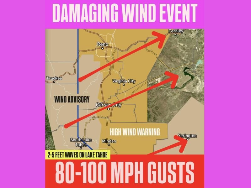
High Wind Warning Covers Western Nevada and Sierra Front
The National Weather Service reports that the strongest winds will develop overnight as a powerful system moves across the Sierra and western Nevada. The highest gusts—potentially nearing 100 mph along ridgetops—pose a serious threat to trees, power lines, and high-profile vehicles.
Key impacts include:
- 80 mph gusts along US-395 and I-580
- 100 mph gusts on exposed ridgetops
- 50 mph winds around Lake Tahoe, capable of generating 2–5 foot waves
- 15–30 mph sustained winds in valley areas
Authorities urge residents to prepare for outages, secure outdoor items, and limit travel during peak winds.
Hazardous Travel Expected Through Early Monday
Strong crosswinds will make travel dangerous for trucks, RVs, buses, and other high-profile vehicles, particularly on:
- US-395
- I-580
- Highway 50
- Highways surrounding Carson City and Minden
Low visibility from blowing dust is also possible in open and rural areas. Officials caution that even a brief period of severe gusts can lead to overturned vehicles or debris hazards along the road.
Lake Tahoe will experience its own wind-related threats, with waves up to 5 feet expected—posing risks for boaters and lakeside marinas.
Power Outages Likely as Winds Strengthen Overnight
Given the strength of the incoming wind event, utility crews across northern Nevada are preparing for scattered to widespread outages. Falling limbs and whole trees may come down under wind stress, especially in areas already weakened by recent storms.
Emergency officials recommend:
- Charging phones and essential devices
- Having flashlights and batteries on hand
- Avoiding wooded areas or unstable structures
- Staying indoors during peak gusts
Residents should report downed power lines immediately and avoid approaching damaged electrical infrastructure.
Brief Calming Expected After Sunrise, but Impacts May Continue
Although winds are expected to weaken Monday morning, cleanup efforts may continue throughout the day. Road closures, blocked lanes, or lingering power disruptions remain possible even after the strongest winds subside.
Officials advise the public to stay alert for rapidly changing conditions, updates from the National Weather Service, and local emergency notifications. For continuing coverage of severe weather threats across the West and nationwide updates, visit NapervilleLocal.com.

I’ve lived in Naperville long enough to see how quickly our community changes — from new developments downtown to sudden shifts in our Midwest weather. Reporting on Naperville news and daily forecasts gives me the chance to keep neighbors informed about what really matters. My goal is simple: deliver clear, timely updates so you always know what’s happening in our city and what to expect from the skies above.