
Dangerous Overnight Storm Threat Sunday From Arkansas to Indiana Could Bring 70+ MPH Winds and Tornadoes While Many Are Sleeping
UNITED STATES — Meteorologists are warning that a dangerous severe weather event could unfold Sunday night across parts of the central United States, with a powerful line of storms expected to sweep from Arkansas through the Mississippi Valley and into Indiana.
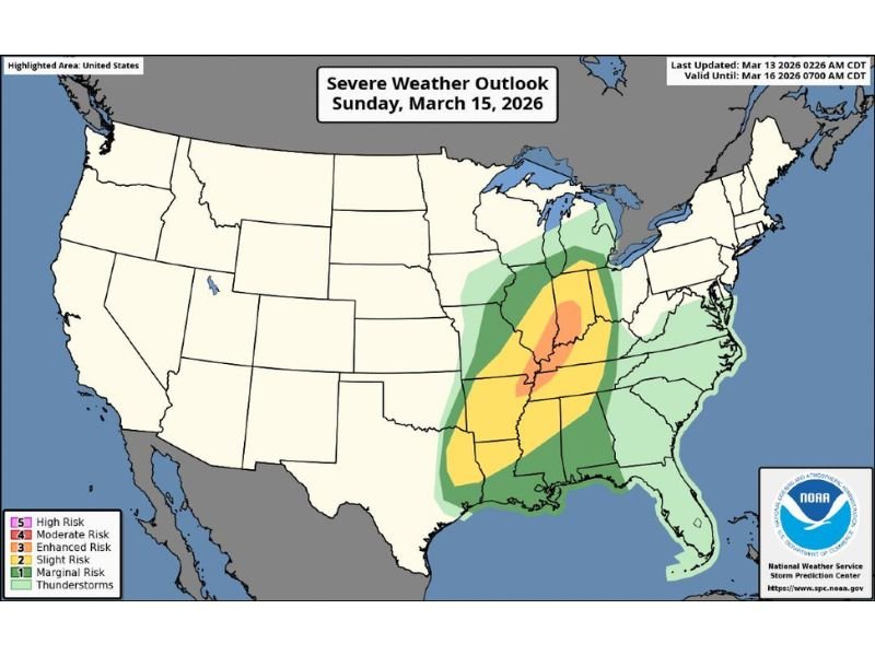
Early outlooks from forecasters already place portions of the region under an Enhanced Risk for severe weather, signaling the potential for widespread damaging winds and embedded tornadoes as the system intensifies.
Powerful Squall Line Expected to Develop Sunday Night
Forecast models indicate that a large squall line of thunderstorms could organize Sunday evening and race northeast overnight, creating the potential for widespread wind damage.
These storms could produce wind gusts exceeding 70 mph, strong enough to knock down trees, damage roofs, and cause scattered power outages. Because the storms are expected to move through during overnight hours, the timing raises concerns that many residents may be asleep when the most dangerous conditions arrive.
Severe Weather Risk Stretching Across Multiple States
The current severe weather outlook highlights a broad corridor of risk stretching from Arkansas and northern Louisiana through Mississippi, Tennessee, Kentucky, Illinois, and Indiana.
Within this region, the highest concentration of severe weather potential currently centers across parts of the lower Mississippi Valley and mid-Mississippi Valley, where the atmosphere could support stronger storm development. Communities across this corridor could face damaging straight-line winds, intense thunderstorms, and the possibility of embedded tornadoes within the squall line.
Tornado Threat Possible Within the Storm Line
While damaging winds are expected to be the primary threat, meteorologists warn that tornadoes could develop within rotating storm segments embedded in the line.
These types of storms can produce brief but dangerous tornadoes that form quickly and move rapidly, making them particularly hazardous during nighttime hours. Residents across the risk area are encouraged to monitor weather updates closely as the event approaches.
Storm System Expected to Move Quickly Across the Region
Forecast projections suggest the storm line could rapidly push northeast overnight, impacting multiple states in a relatively short period of time. Such fast-moving systems can spread severe weather impacts across a wide area, increasing the potential for widespread damage reports across several states by early Monday morning.
Forecasters Monitoring Storm Evolution Ahead of Sunday
Although the event is still several days away, meteorologists say the overall setup for a widespread severe weather outbreak is already becoming evident in forecast models. Officials stress that residents across the potential impact zone should stay alert for updated forecasts over the coming days, as details regarding timing and exact storm impacts continue to evolve.
Emergency preparedness experts also recommend ensuring weather alerts are enabled on phones and weather radios, especially since the most intense storms could occur overnight when people are less likely to notice warning signs.

I’ve lived in Naperville long enough to see how quickly our community changes — from new developments downtown to sudden shifts in our Midwest weather. Reporting on Naperville news and daily forecasts gives me the chance to keep neighbors informed about what really matters. My goal is simple: deliver clear, timely updates so you always know what’s happening in our city and what to expect from the skies above.