
Dangerous Severe Weather Locks In Across Minneapolis, Rochester, Milwaukee, and Chicago With Very Large Hail, Damaging Winds, and Strong Tornadoes Possible Through the Evening
MINNEAPOLIS, Minn. — A dangerous and high-impact severe weather setup is locked and loaded across a large swath of the Midwest today, with the environment primed for big-time hailstorms and a significant tornado risk between 3 and 10 PM. Very large hail, damaging winds, and a couple of strong tornadoes are all on the table this afternoon and evening, with the most intense and concentrated danger zone centered over Minneapolis, Rochester, and the surrounding region. The window is tight but the threat is very real — residents across the affected area need to act now before storms arrive.
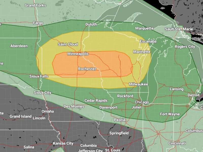
Enhanced Risk Zone Targets Minneapolis and Rochester
The core of today’s dangerous setup — shown in orange on the severe weather outlook — is centered directly over Minneapolis and Rochester, Minnesota, extending eastward through portions of Wisconsin. This enhanced risk zone represents the area with the highest probability of experiencing the most significant and organized severe weather between 3 and 10 PM today.
Communities including Saint Cloud, Sioux Falls, and Sioux City sit within the surrounding Slight Risk yellow zone, where severe weather is still very much possible but slightly less concentrated than in the orange core. The broader Marginal Risk in green reaches outward to cover Fargo, Duluth, Marquette, Marinette, Milwaukee, Rockford, Chicago, Joliet, Davenport, Cedar Rapids, Des Moines, and Omaha — a massive geographic footprint of at least some severe weather concern stretching from the northern plains through the Great Lakes corridor.
Very Large Hail and Big-Time Hailstorms Expected
The environment today is described as primed specifically for big-time hailstorms — not just garden-variety severe weather hail, but very large stones capable of causing serious damage to vehicles, rooftops, windows, and anything left exposed outdoors. Residents across the enhanced and slight risk zones should move vehicles into covered parking immediately and bring in any outdoor furniture, trampolines, decorations, or other items that could be damaged or become dangerous projectiles in large hail.
The combination of strong instability, deep wind shear, and moisture in place today creates ideal conditions for supercell thunderstorms — the storm type most efficient at producing very large hail alongside other hazards.
Strong Tornadoes Possible Between 3 and 10 PM
Beyond hail, a couple of strong tornadoes are considered possible with today’s setup. The 3 to 10 PM window is the primary tornado threat period, and any supercell that develops and maintains its structure during those hours could produce a significant tornado with limited warning time.
Residents in the Minneapolis metro, Rochester, Saint Cloud, and communities across southern Minnesota and western Wisconsin should identify their shelter location right now — before the afternoon heating triggers storm development. Do not wait for a tornado warning to start thinking about where to go.
Broader Midwest on Alert From Chicago to Des Moines
While the orange zone carries the highest danger, the broader green marginal risk zone is not something communities like Chicago, Rockford, Joliet, Milwaukee, Cedar Rapids, and Des Moines should dismiss. Any storm that tracks through these areas between 3 and 10 PM has the potential to produce damaging winds, hail, and brief tornado activity even in the lower-tier risk zones.
Secure vehicles, pets, and outdoor belongings now, keep weather alerts active all afternoon and evening, and stay tuned for live storm coverage updates throughout the dangerous weather window today. Stay with NapervilleLocal.com for the latest weather updates and local forecast coverage.

I’ve lived in Naperville long enough to see how quickly our community changes — from new developments downtown to sudden shifts in our Midwest weather. Reporting on Naperville news and daily forecasts gives me the chance to keep neighbors informed about what really matters. My goal is simple: deliver clear, timely updates so you always know what’s happening in our city and what to expect from the skies above.