
Dense Fog Advisory Expanded Across Central Florida Including Orlando and Tampa, Dangerous Visibility Expected Until 10AM
FLORIDA — A dense fog advisory has been expanded across parts of Central Florida early this morning, including the Orlando area, with dangerously low visibility possible through 10 a.m., according to the latest advisory map.
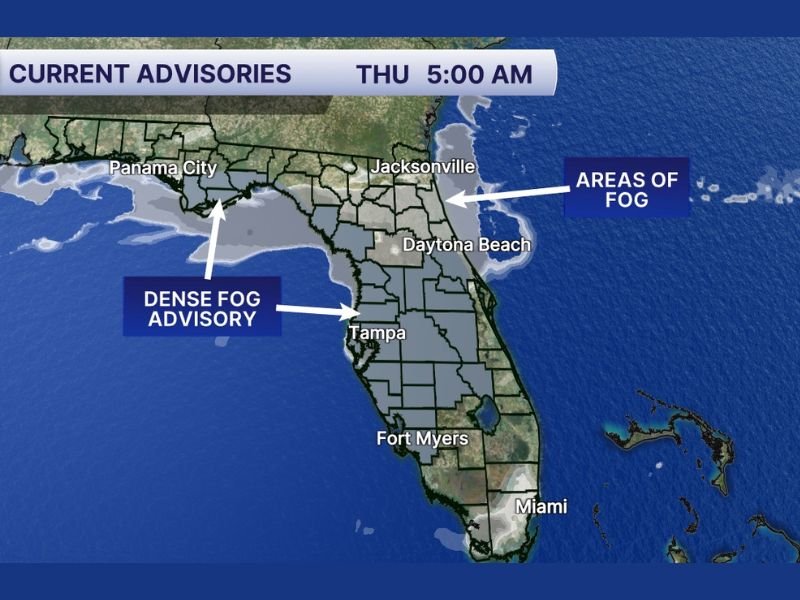
The 5:00 a.m. update shows widespread fog stretching along portions of the Gulf Coast and inland across Central Florida. The advisory highlights Tampa and surrounding areas, with additional fog coverage extending north toward Panama City and east toward Jacksonville and Daytona Beach.
Fog Impacting Gulf Coast and Inland Central Florida
The advisory shading on the map indicates thick fog across much of the west-central peninsula, including the Tampa Bay region. Areas along the Gulf Coast are especially vulnerable during the early morning hours, when visibility can quickly drop to near zero in localized spots.
Panama City is also shown within the advisory area along the northern Gulf Coast. Inland communities surrounding Tampa are under the same warning, suggesting travel conditions could be hazardous across a broad stretch of central and western Florida.
Orlando Area Now Included in Advisory
The update specifically notes that the advisory has been extended into the Orlando area. That expansion suggests fog has either developed or is expected to develop farther east than earlier forecasts indicated.
Motorists traveling around Orlando, particularly during the early morning commute, may encounter sudden reductions in visibility. Fog can be uneven and patchy, meaning one roadway may appear clear while another nearby becomes obscured within seconds.
East Coast Seeing Areas of Fog
The map also identifies “areas of fog” along Florida’s Atlantic coastline, including near Jacksonville and Daytona Beach. While not all of these locations appear to be under the densest advisory shading, visibility reductions are still possible.
Drivers along I-95 and other major corridors in northeast Florida should remain alert for sudden changes in road conditions, especially near bridges, waterways, and low-lying areas where fog tends to thicken.
When Conditions Should Improve
According to the advisory information, the most dangerous visibility issues are expected through 10 a.m. As the sun rises higher and temperatures warm, fog typically begins to thin and lift.
However, improvement can be gradual. In some inland or coastal pockets, reduced visibility may linger slightly beyond mid-morning depending on wind conditions and surface moisture.
Travel Safety Reminders
Anyone traveling across Central Florida and the Gulf Coast this morning should use extra caution:
• Slow down and allow additional stopping distance
• Use low-beam headlights — not high beams
• Avoid sudden braking or lane changes
• Stay alert for rapidly changing visibility conditions
Dense fog can be especially dangerous on highways and near water, where moisture levels are highest. Motorists are urged to delay travel if possible until visibility improves later this morning. For continued updates on weather advisories and travel impacts, stay connected with NapervilleLocal.com as we monitor changing conditions across the region.

I’ve lived in Naperville long enough to see how quickly our community changes — from new developments downtown to sudden shifts in our Midwest weather. Reporting on Naperville news and daily forecasts gives me the chance to keep neighbors informed about what really matters. My goal is simple: deliver clear, timely updates so you always know what’s happening in our city and what to expect from the skies above.