
Don’t Let the Calm Morning Fool You: Northwest Ohio Faces Low Risk of Severe Storms After 8 PM With Damaging Winds, Hail, and a Non-Zero Tornado Threat
TOLEDO, Ohio — Ohio is enjoying a relatively quiet start to the day, but forecasters are urging residents — especially those in the northwestern corner of the state — not to let the calm morning hours lower their guard.
Severe weather is possible later today, with a stronger and more organized line of storms expected to push into Northwest Ohio after 8 PM. While this is not anticipated to be a major outbreak, forecasters are clear about one sobering reality — it only takes one storm to become a very big deal for the spot it hits.
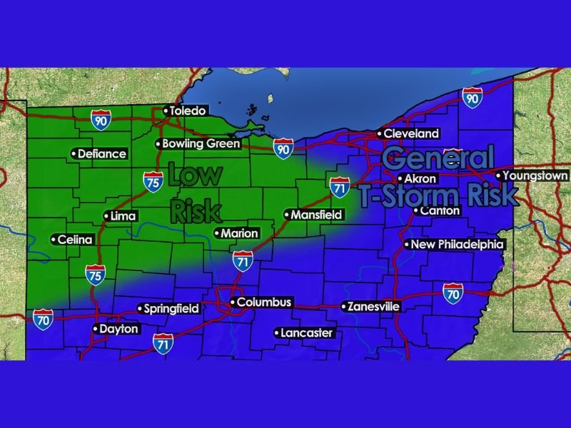
Two-Tiered Risk Splits Ohio Down the Middle
The threat today is divided into two distinct zones across the state. Northwestern Ohio — including Toledo, Defiance, Bowling Green, Lima, Celina, and Marion — falls under a Low Risk designation for severe storms, meaning organized and potentially dangerous storm activity is more likely here than anywhere else in the state today.
Eastern Ohio — covering Cleveland, Akron, Canton, Youngstown, New Philadelphia, Mansfield, and Zanesville — sits under a General Thunderstorm Risk, indicating non-severe storm activity is the more likely outcome for those communities. Columbus, Dayton, Springfield, and Lancaster fall in the transitional zone between the two risk levels.
Scattered Rain and Storms Through the Day — Then It Gets Serious After 8 PM
Scattered rain and storms will be possible at various points through the afternoon hours, but coverage will be uneven and not everyone will get hit during the daytime hours. The more significant and concerning threat arrives after dark.
After 8 PM, a stronger and better-organized line of storms is expected to push into Northwest Ohio, bringing with it the highest potential for severe weather of the entire day. Residents in Toledo, Defiance, Bowling Green, Lima, and surrounding communities should treat the post-8 PM window as the primary period of concern and avoid being caught unprepared heading into the evening.
Damaging Winds and Hail Are the Main Threats
The headline hazards with tonight’s storm line are damaging wind gusts and hail. A well-organized line of storms moving into the region after 8 PM would have the structure needed to produce both hazards efficiently, and residents should take precautions accordingly — securing outdoor furniture and loose items before evening arrives.
The tornado risk is being characterized as low but not zero. While a tornado is not the expected outcome of tonight’s setup, the possibility cannot be completely dismissed, and any rotating storm cell embedded in the line would deserve immediate attention and shelter action from those in its path.
Timing Is Everything With Tonight’s Storms
One of the most important factors in determining how dangerous tonight’s storms become is timing. Forecasters are explicit — an earlier arrival of the storm line means stronger potential, while a later arrival would find a more stable atmosphere and likely produce weaker storms overall.
This timing uncertainty is exactly why residents should not wait to see how the evening unfolds before making a plan. Have a shelter location identified, keep weather alerts active on your phone, and monitor updated forecasts through the afternoon and early evening as the storm line approaches from the west. Stay with NapervilleLocal.com for the latest weather updates and local forecast coverage.

I’ve lived in Naperville long enough to see how quickly our community changes — from new developments downtown to sudden shifts in our Midwest weather. Reporting on Naperville news and daily forecasts gives me the chance to keep neighbors informed about what really matters. My goal is simple: deliver clear, timely updates so you always know what’s happening in our city and what to expect from the skies above.