
Early Forecast Models Signal Potential for Major Snowstorm in the Northeast on December 6–7
UNITED STATES — Long-range weather models are pointing to a developing snowstorm pattern for the northeastern United States late next week, raising early signals for a potentially significant winter storm around December 6–7. While still several days away, the European ensemble forecast (ECMWF EPS) shows an impressive setup of cold air, low pressure, and strong atmospheric energy that could bring heavy snow and strong winds to parts of the Northeast if trends continue.
Meteorologists caution that it is too early to predict exact snowfall amounts or locations, but the model ensemble highlights a high-impact setup worth monitoring closely as the system approaches.
Forecast Models Indicate Strong Upper-Level Trough Over the East
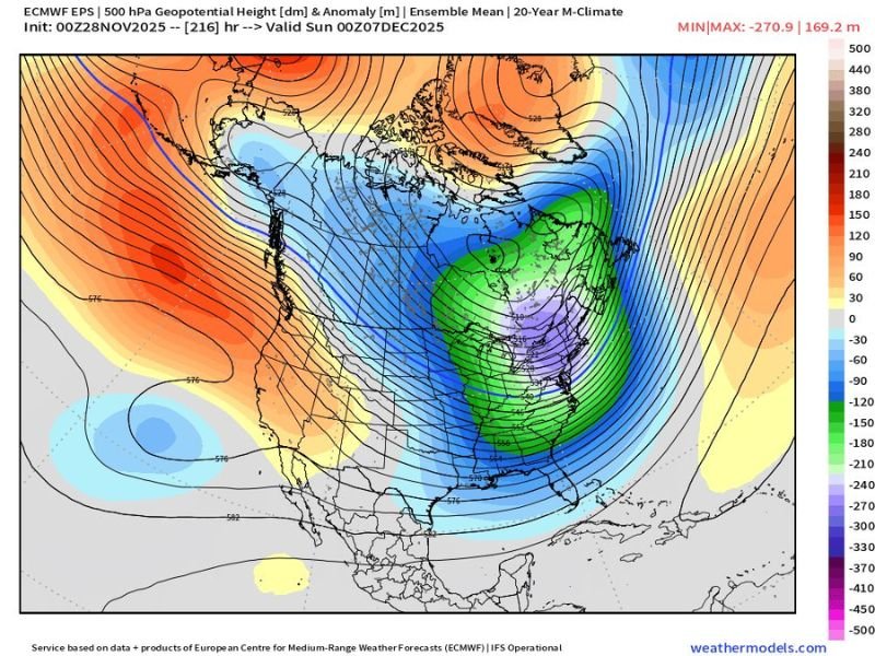
The ECMWF ensemble map shows a deep upper-level trough forming across the eastern half of the country, indicated by widespread blue and green shading, which represents below-normal atmospheric heights and colder air aloft. This feature suggests that a strong low-pressure system could develop, drawing Gulf and Atlantic moisture northward into the Northeast corridor.
Such a setup is typical of major East Coast snowstorms, particularly when Arctic air from Canada interacts with a strengthening low tracking along the coast or through the Ohio Valley.
If this scenario plays out, the storm track would determine who receives heavy snow, mixed precipitation, or mainly rain — with interior sections of New York, Pennsylvania, and New England currently favored for the greatest snow potential.
Early Indicators of a High-Impact System
The European ensemble mean shows a large region of anomalously low geopotential heights across the eastern U.S., with strong ridging (warm air) over the western states. This west-to-east contrast typically promotes an active storm corridor across the central and eastern United States.
Meteorologists say the model run is notable for the intensity and size of the trough, which supports a broad storm system capable of affecting multiple states. If the current guidance holds, this system could bring:
- Heavy snowfall across interior Northeast and parts of the Mid-Atlantic
- Strong winds capable of causing blowing snow and power outages
- Coastal impacts including high surf or minor flooding in some areas
While it’s still early in the forecast period, experts emphasize that this setup has a classic signature for a large winter storm, especially during early December transitions.
What Meteorologists Are Watching
Weather analysts are monitoring several key factors that will determine whether the storm materializes and how strong it becomes:
- Storm Track: A farther east track would favor snow for the interior Northeast, while a westward track could bring rain or mixed precipitation closer to the coast.
- Timing of Cold Air: The arrival of Arctic air ahead of the system will be crucial for establishing widespread snow.
- Moisture Source: Gulf and Atlantic moisture feed will dictate the intensity and reach of precipitation bands.
Updates from the European (ECMWF) and American (GFS) models over the next several days will clarify whether the system remains consistent or trends weaker.
Too Early for Totals, But Confidence Increasing
Forecasters stress that it’s premature to discuss snowfall totals at this range — more than a week out — but the ensemble consistency across multiple runs suggests the potential is real. Confidence remains medium at best for now, but meteorologists agree this is one to watch closely throughout the week.
If the cold air locks in and the low pressure tracks along the ideal path, parts of the Northeast and Great Lakes could experience their first major snow event of the winter season.
Residents from Pennsylvania to Maine are encouraged to stay weather-aware, especially those planning travel next weekend. Forecast confidence will increase as new model data arrives midweek.
Stay with NapervilleLocal.com for verified updates and detailed forecasts as new data emerges on this developing Northeast winter storm potential.

I’ve lived in Naperville long enough to see how quickly our community changes — from new developments downtown to sudden shifts in our Midwest weather. Reporting on Naperville news and daily forecasts gives me the chance to keep neighbors informed about what really matters. My goal is simple: deliver clear, timely updates so you always know what’s happening in our city and what to expect from the skies above.