
Early January Heat Surge Expected Across Texas and the Central U.S., With Temperatures 10–15 Degrees Above Normal and Near-Record Highs in North Texas
TEXAS — A significant warm-up is expected across Texas and the central United States during the first week of January, with temperatures rising 10 to 15 degrees above seasonal averages and the potential for near-record highs in North Texas. After several recent cold fronts, the upcoming pattern shift will bring widespread warmth and abundant sunshine to start the new year.
Forecasters say the first few days of January will feature an early return of springlike temperatures, particularly across the southern Plains. The warmest stretch is expected late in the week, when highs in parts of North Texas could challenge long-standing temperature records.
Warm Pattern Returns With Temperatures Well Above Normal
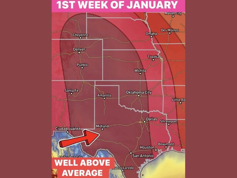
Weather models highlight a broad area of warmer-than-average air expanding across the central U.S., covering Texas, Oklahoma, Kansas, Nebraska, and sections of Colorado and New Mexico. Anomalies of 10 to 15 degrees above climatological norms will be common, marking one of the mildest openings to January in recent years.
Cities including Dallas, Fort Worth, Wichita, Oklahoma City, and Denver are expected to fall within the core of this warm zone. Forecast maps show deep red shading across much of the central region, indicating widespread above-normal highs and noticeably warmer afternoons.
This setup is typical when strong high pressure builds across the southern United States, suppressing cloud cover and allowing temperatures to climb quickly.
North Texas Could Approach Record Highs Near 78 Degrees
North Texas stands out as one of the areas most likely to break or challenge temperature records. The current January 3 record high in the DFW region is 78 degrees, and forecasts suggest temperatures may come close to that mark under sunny and dry conditions.
If realized, this would be the region’s newest in a streak of warm temperature milestones. DFW has already recorded nine record highs since October, underscoring the frequency of unseasonable warmth during the fall and early winter months.
The return of 70-degree temperatures will offer a notable contrast to recent cold spells and may give residents a brief taste of spring before the next pattern shift develops later in the month.
Warmth Extends Across the Central and Southern Plains
Beyond Texas, the warm spell will stretch northward into Kansas, Nebraska, and eastern Colorado, where highs will climb well above what is typical for early January. Areas from Cheyenne to Pueblo and Amarillo could see temperatures rise dramatically as the warm air expands through the Plains.
This type of regional warming often reduces the chance of widespread winter precipitation during its duration, as elevated temperatures suppress snow development and weaken storm systems attempting to move into the middle of the country.
Meteorologists note that this warm pattern may not last for the entire month but will dominate the first week, setting up a stark contrast from the colder, stormier pattern expected later in January.
Short-Term Warmth Before Possible Mid-January Pattern Shift
While the first week of January is poised to bring mild and tranquil weather, longer-range forecasts indicate a potential shift back to colder and more active conditions by mid-month. This could lead to a return of winter storms as blocking patterns develop across the northern hemisphere.
For now, residents across Texas and the Plains can expect a stretch of warm, pleasant afternoons and relatively quiet weather as 2026 begins. NapervilleLocal.com will continue monitoring temperature trends and the evolving January outlook as more data becomes available.

I’ve lived in Naperville long enough to see how quickly our community changes — from new developments downtown to sudden shifts in our Midwest weather. Reporting on Naperville news and daily forecasts gives me the chance to keep neighbors informed about what really matters. My goal is simple: deliver clear, timely updates so you always know what’s happening in our city and what to expect from the skies above.