
East Coast Winter Storm Signals Grow Stronger in AI Models, With Heavier Snow Potential Along I-95 Corridor
UNITED STATES — Long-range forecast models are beginning to align on a potentially significant winter storm along the East Coast next week, with artificial intelligence–driven guidance showing a colder and snowier solution than some traditional models.
Forecasters are closely watching new runs of the AIFS (AI Forecast System) and the European AI model, both of which are now hinting at a similar setup developing roughly a week from now. The biggest difference in the latest projections? A notably colder look along the I-95 corridor, increasing the chances for accumulating snow in major metropolitan areas.
AI Models Showing Consistent Coastal Low Development
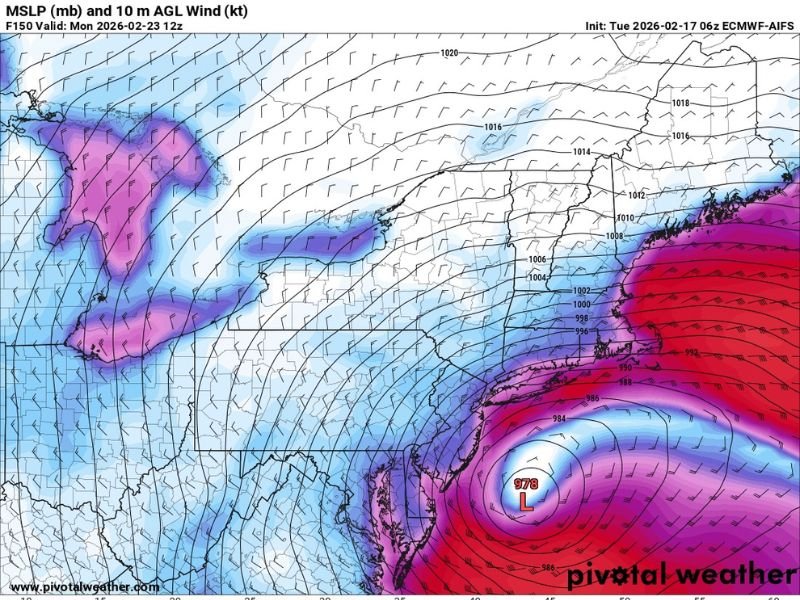
Recent data suggests a strengthening coastal low-pressure system developing offshore of the Mid-Atlantic and Northeast. One projected solution places the low around 978 mb near the coast — a signal of a fairly strong storm system capable of producing heavy precipitation and gusty winds.
Wind field projections show a tightly wrapped circulation off the East Coast, drawing Atlantic moisture inland. That setup would support widespread precipitation from the Mid-Atlantic into southern New England.
What’s drawing attention is how both AI-based models are beginning to converge on a similar outcome at this extended range.
Colder Air Along the I-95 Corridor
The European AI model in particular is showing a colder thermal profile along Interstate 95, including cities such as Washington, D.C., Philadelphia, New York City, and Boston. If that colder air holds in place, precipitation would fall primarily as snow rather than rain across much of the urban corridor.
Projected snowfall totals in some model runs are substantial across parts of the Mid-Atlantic and Northeast, with higher amounts stretching inland and into southern New England. While exact totals remain highly uncertain at this range, the signal for a widespread winter weather event is becoming more noticeable.
Model Differences and Uncertainty
One interesting wrinkle is how the AIFS behaves depending on the model cycle. Some runs (6z and 18z) appear more locked into the storm scenario, while others (0z and 12z) show a more suppressed system tracking farther offshore.
That type of variability is not unusual at this lead time. However, forecasters note that AI-based models have recently performed better than legacy guidance at the one-week range, which is why these projections are gaining attention.
Still, it’s important to emphasize that this remains a long-range outlook. Small shifts in the storm track — even by 50 to 100 miles — could dramatically change impacts along the I-95 corridor, determining who sees heavy snow, a mix, or mostly rain.
What It Means Right Now
For now, this is an early heads-up rather than a forecast set in stone. The developing signal suggests:
- A coastal storm is possible late next week.
- Colder air could support snow along portions of the East Coast.
- Major cities along I-95 may need to monitor trends closely.
Confidence will increase as we move closer within the five-day window and model agreement improves.
NapervilleLocal.com will continue tracking significant national weather developments that could impact travel, commerce, or Midwest connections in the days ahead. Stay with us for updates as forecast confidence builds.

I’ve lived in Naperville long enough to see how quickly our community changes — from new developments downtown to sudden shifts in our Midwest weather. Reporting on Naperville news and daily forecasts gives me the chance to keep neighbors informed about what really matters. My goal is simple: deliver clear, timely updates so you always know what’s happening in our city and what to expect from the skies above.