
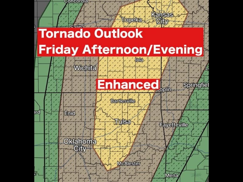
Eastern Oklahoma Including Tulsa Placed Under Enhanced Tornado Risk Friday Afternoon as Supercell Storms Expected to Develop
Eastern Oklahoma — Forecasters are warning that tornado potential will increase Friday afternoon and evening across eastern Oklahoma, where the Storm Prediction Center has placed a large portion of the region — including Tulsa and surrounding communities — under an Enhanced Risk for severe storms.
Meteorologists say a powerful storm system moving into the Plains will create favorable conditions for severe weather development later in the day. Thunderstorms are expected to begin forming during the late afternoon hours, especially after 4 PM, when atmospheric instability increases.
If storms organize as expected, they could produce tornadoes, large hail, and damaging winds, making Friday a potentially dangerous weather day across eastern Oklahoma and nearby parts of the Plains.
Enhanced Severe Weather Risk Covers Eastern Oklahoma
The Enhanced Risk category issued by the Storm Prediction Center represents a higher level of concern for organized severe weather events.
This risk area includes much of eastern Oklahoma, with cities such as:
- Tulsa
- Bartlesville
- McAlester
- Enid
- Oklahoma City
also located near the broader severe weather zone.
In addition, areas across southeastern Kansas and parts of northwestern Arkansas, including communities near Joplin and Fayetteville, may also experience strong storms as the weather system spreads eastward.
Meteorologists note that the core tornado risk appears centered around eastern Oklahoma, where atmospheric conditions will likely become increasingly unstable during the afternoon.
Tornadoes, Large Hail, and Damaging Winds Possible
Forecast guidance suggests several severe weather hazards could accompany these storms.
The main threats include:
- Possible tornado development
- Large hail capable of damaging vehicles and property
- Damaging wind gusts that could exceed severe storm thresholds
The atmosphere across the Plains is expected to feature strong wind shear, which helps thunderstorms rotate. When combined with rising warm air, this setup can lead to supercell thunderstorms, the type of storm most commonly associated with tornadoes.
Forecasters say that initial storms may form as isolated supercells, which often produce the strongest tornado potential before storms merge into larger clusters or lines.
Storms Likely to Form After 4 PM Friday
The most active period for severe weather is expected to begin late Friday afternoon and continue into the evening hours. Meteorologists indicate that storm development will likely begin after 4 PM, as the approaching storm system interacts with warm, unstable air across Oklahoma and surrounding states.
Early storms could develop rapidly and intensify quickly, especially if they remain isolated during the first stages of development. Later in the evening, storms may organize into a larger line of thunderstorms, shifting the primary threat toward damaging winds while still maintaining the possibility of embedded tornadoes.
Why Meteorologists Are Monitoring This Setup Closely
The combination of increasing atmospheric instability and strong wind shear is creating a weather environment favorable for severe thunderstorms. In particular, the presence of rotating supercells before storms merge into a larger system could increase the chances of tornado development across parts of eastern Oklahoma.
Weather experts stress that residents across Tulsa and surrounding communities should remain weather aware Friday afternoon and evening, as conditions could change rapidly if storms intensify.
Officials recommend monitoring local forecasts and having multiple ways to receive severe weather alerts, especially in areas located within the Enhanced Risk zone. For continued updates on severe weather developments and major weather events affecting communities across the United States, readers can stay informed with the latest reports on NapervilleLocal.com.

I’ve lived in Naperville long enough to see how quickly our community changes — from new developments downtown to sudden shifts in our Midwest weather. Reporting on Naperville news and daily forecasts gives me the chance to keep neighbors informed about what really matters. My goal is simple: deliver clear, timely updates so you always know what’s happening in our city and what to expect from the skies above.