
Eastward Shift Cuts Central Pennsylvania Snow Totals, but Delaware to Southern New England Still Targeted for 1–2 Feet and Blizzard Conditions
UNITED STATES — An 11 a.m. forecast update confirms a significant eastward shift in the developing Nor’easter, dramatically changing snowfall expectations for parts of Pennsylvania while leaving the coastal corridor from Delaware to southern New England firmly in the zone for heavy snow and blizzard conditions.
Forecasters say the storm will not track close enough to the New Jersey coast to pull the strongest deformation band into eastern and central Pennsylvania. As a result, central Pennsylvania is now expected to fall short of earlier Winter Storm Warning projections, and the extreme 2–4 foot totals once hinted at in southern New Jersey are no longer supported by the latest data.
Central Pennsylvania Totals Reduced
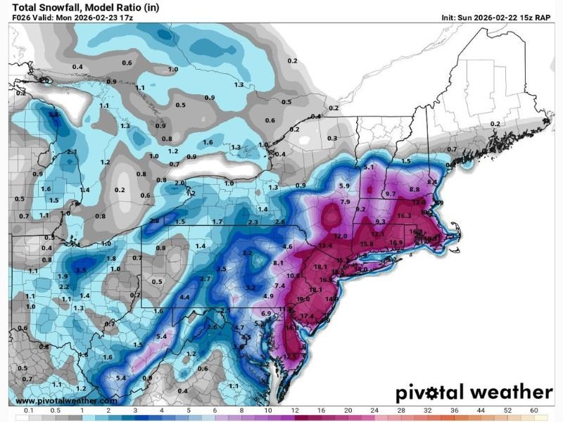
The updated snowfall projection map shows noticeably lighter totals across much of central and western Pennsylvania compared to earlier runs. Many inland areas that were once projected for high-end accumulations are now trending closer to modest totals.
Meteorologists note that high snowfall projections are unlikely to verify across most of Pennsylvania, except possibly in southeastern Pennsylvania (SEPA), where heavier banding may still clip the region.
In short, the worst-case snowfall scenario for much of the state is off the table.
Pocono Mountains Still Positioned for Blizzard Conditions
Despite the eastward shift, the Poconos remain in a favorable position for heavy snow. Orographic lift combined with strong winds could allow this higher-elevation region to maintain intense snowfall rates.
Forecasters indicate winds there may be strong enough to meet blizzard criteria, meaning sustained strong winds combined with falling and blowing snow could significantly reduce visibility.
Coastal Plain From Delaware to Southern New England Remains Prime Target
While Pennsylvania sees reduced expectations, the forecast remains robust for coastal areas stretching from Delaware through New Jersey, New York City, Long Island, Connecticut, Rhode Island, and into southern Massachusetts.
Model guidance continues to show a corridor of:
- 12–18 inches widespread
- Localized totals exceeding 18 inches
- Strong winds capable of producing blizzard conditions
The updated snow map highlights the heaviest accumulations concentrated closer to the coast, with inland totals tapering off sharply westward.
Travel and Impact Outlook
With the core of the storm hugging the coast, major metro areas along the I-95 corridor remain vulnerable to hazardous travel, low visibility, and significant disruptions. Meanwhile, central Pennsylvania may avoid the worst-case impacts that were previously feared.
As the storm evolves, small shifts in track could still alter totals locally, but the broader message is clear: coastal zones remain in line for high-impact winter weather, while much of Pennsylvania trends lower than earlier projections.
For continued updates and in-depth analysis of major national storm systems, stay connected with NapervilleLocal.com.

I’ve lived in Naperville long enough to see how quickly our community changes — from new developments downtown to sudden shifts in our Midwest weather. Reporting on Naperville news and daily forecasts gives me the chance to keep neighbors informed about what really matters. My goal is simple: deliver clear, timely updates so you always know what’s happening in our city and what to expect from the skies above.