
Expanded Marginal Severe Risk Across North and Central Texas as Slow-Moving Storm Threatens 50–60 MPH Winds and Heavy Rain Through Valentine’s Night
TEXAS — A slow-moving storm system is expanding its reach across North and Central Texas, bringing an expanded marginal severe risk that could last well into Valentine’s night and even past midnight in some areas. Forecasters warn that showers and thunderstorms will intensify through Saturday morning, with the strongest activity expected by midday and into the afternoon.
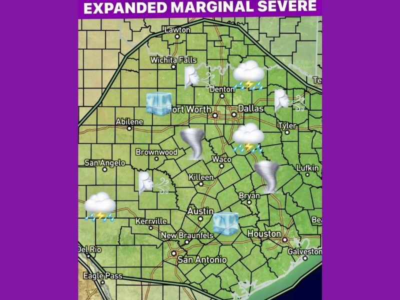
The latest outlook highlights a broad area stretching from near Lawton and Wichita Falls southward through the Dallas–Fort Worth Metroplex, Abilene, Waco, Austin, San Antonio, and toward Houston and the Upper Texas Coast. Much of this region is now included in the expanded marginal risk zone.
Storm Timing and Impact Window
Storms are expected to build out west during the mid-morning hours Saturday, then spread eastward. By around noon, much of the Dallas–Fort Worth area could be locked into periods of heavy downpours.
The main severe window runs:
- Mid-morning Saturday
- Through Saturday afternoon and evening
- Potentially lingering past midnight into early Sunday
A second piece of upper-level energy is expected to move in Valentine’s night, prolonging storm chances and extending rainfall totals.
What Hazards Are Possible?
Stronger storm cells may produce:
- Wind gusts between 50 and 60 mph
- Small hail, generally quarter-size or less
- Frequent lightning
- Localized heavy rainfall
- A brief isolated spin-up tornado cannot be ruled out
While the overall risk category remains “marginal,” the combination of strong winds and downpours could cause isolated damage or travel disruptions, especially during peak activity Saturday afternoon.
Rainfall Totals and Flooding Concerns
Rainfall amounts of 1 to 2 inches are possible across parts of North and Central Texas. With the system slowing down, some localized areas could see brief heavier bursts that may lead to ponding on roads or minor flooding in low-lying spots. The wrap-around moisture on the backside of the system could keep scattered showers going into the early hours of Sunday before conditions improve.
A Much Calmer Sunday Ahead
After the storm clears out, Sunday is expected to bring a noticeable improvement. Sunshine and highs in the upper 60s are forecast across much of the region, offering a welcome break after a stormy Saturday.
Although this system is centered well south of Illinois, large storm patterns across the Southern Plains often signal broader shifts in national weather trends. NapervilleLocal.com will continue monitoring major weather systems that could eventually influence Midwest conditions.

I’ve lived in Naperville long enough to see how quickly our community changes — from new developments downtown to sudden shifts in our Midwest weather. Reporting on Naperville news and daily forecasts gives me the chance to keep neighbors informed about what really matters. My goal is simple: deliver clear, timely updates so you always know what’s happening in our city and what to expect from the skies above.