
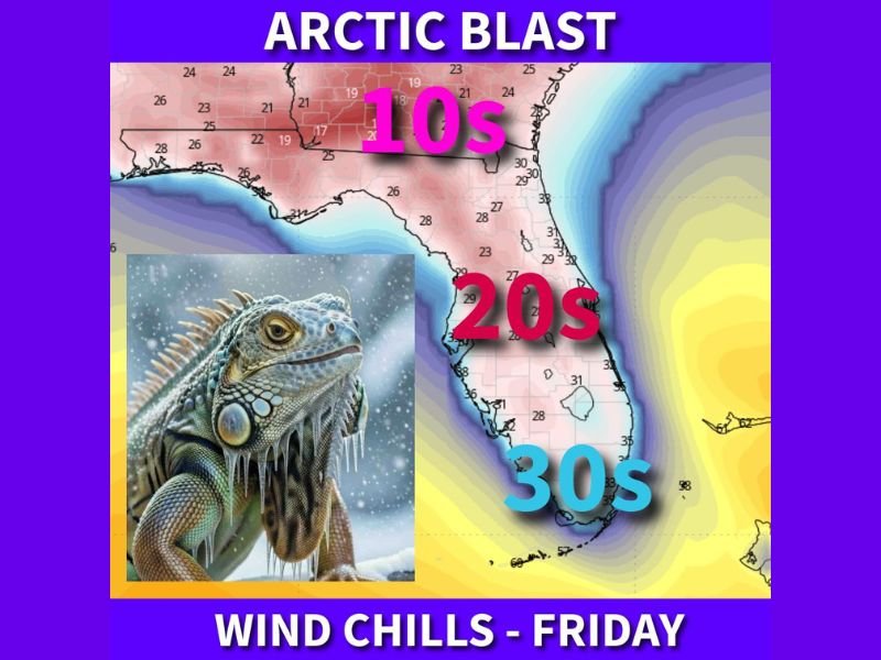
Florida Braces for Another Arctic Blast as Cold Front Brings Wind Chills in the 10s and 20s Friday
FLORIDA — Another sharp cold snap is lining up for the Sunshine State this week, with a strong cold front expected Thursday and a quick slide back into dangerous-feeling wind chills by Friday morning, including teens in the Panhandle and 30s reaching deep into South Florida, based on the forecast details shown in the update.
Cold Front Thursday Sets Up a Much Colder Friday Morning
The outlook describes a familiar winter pattern for Florida: a front sweeps through, then the cold air rushes in behind it fast. By Friday, the map and summary point to a statewide plunge in “feels-like” temperatures, with the coldest conditions concentrated in the northern half of the state.
The graphic highlights a clear wind-chill breakdown:
- Panhandle: Wind chills dropping into the 10s
- North and Central Florida: Wind chills in the 20s
- South Florida: Wind chills sliding into the 30s
That matters because wind chills can turn an otherwise “cool” temperature into something that feels punishing outdoors, especially during early morning hours when conditions are typically at their coldest.
Why This Cold Blast Could Be a Bigger Deal Than the Numbers Look
Even though Florida is used to quick cold shots, this one is framed as an “arctic blast” because it combines cold air with enough wind to make it feel significantly worse than thermometer readings alone.
For residents, that often means:
- A rough commute for anyone waiting outside for buses or working early shifts
- Higher risk for exposed skin discomfort and rapid chilling in windy areas
- Extra stress on pets, outdoor plants, and people without reliable heat
And it is not just people who feel it. The update specifically notes that iguanas won’t like this forecast—a reference to Florida’s well-known “cold-stunned” iguana problem, when temperatures drop enough to slow them down or cause them to fall from trees.
Relief Could Arrive Quickly Next Week
The good news in the forecast is timing: the same update suggests Florida should shake the worst of the cold by early next week as a warmer pattern builds back in. That’s a key point for families and workers trying to plan, because it signals this is likely a short-lived blast rather than a long, grinding freeze.
What Floridians Should Do Now
If you are in Florida, especially across the Panhandle and northern counties, the smartest move is to treat Friday morning like a true cold-weather event: plan for layers, limit long outdoor exposure early, and think ahead for pets, plants, and anyone who may need extra warmth.
What do you think—does it feel like winter keeps “resetting” this year, or is this just one last jab before springlike weather returns? Share your thoughts with us at napervillelocal.com.

I’ve lived in Naperville long enough to see how quickly our community changes — from new developments downtown to sudden shifts in our Midwest weather. Reporting on Naperville news and daily forecasts gives me the chance to keep neighbors informed about what really matters. My goal is simple: deliver clear, timely updates so you always know what’s happening in our city and what to expect from the skies above.