
Florida Braces for “Peak Chill” Friday Morning as Wind Chills Dip Into the Low 20s From Tallahassee to Jacksonville
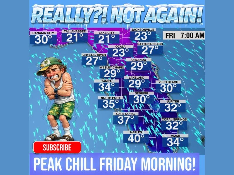
FLORIDA — After a very brief warm-up, Florida is staring down another cold shot, with forecasters warning that peak wind chills will arrive Friday morning around 7:00 a.m. The wind chill map shared in the provided data shows a broad sweep of uncomfortable air across the state, with the coldest “feels-like” numbers centered in North Florida and the chill extending well into the peninsula.
The headline message is simple: don’t let the next cold blast catch you off guard. Even for Floridians used to winter warm spells, this setup signals a fast drop back into a wind-driven cold that can feel sharper than the actual temperature.
Where Friday’s coldest wind chills are expected
The lowest wind chills shown on the map appear across North Florida and the I-10 corridor. Tallahassee is shown at 21°F and Lake City is also shown at 21°F, placing that region at the center of the coldest morning conditions. Jacksonville is shown at 23°F, while Ocala is shown at 23°F, reinforcing that the northern half of the state could feel more like a deep-winter morning than a typical Florida daybreak.
Along the Panhandle and nearby areas, Panama City is shown at 30°F, while Daytona Beach is shown at 27°F. On the Gulf side, Crystal River is shown at 27°F, adding another pocket of late-week chill to the Nature Coast.
Central Florida drops back into the 20s and 30s
Central Florida also takes a hit on this map, especially when wind is factored in. The Friday morning wind chill values shown include Orlando at 29°F, Lakeland at 29°F, and Wesley Chapel at 29°F, all hovering at or just below the freezing mark in “feels-like” terms.
The Tampa Bay region appears less extreme than North Florida but still cold by local standards, with Tampa shown at 34°F. Farther south on the Gulf Coast, the values begin to inch upward, but remain chilly, with North Port shown at 35°F, Cape Coral shown at 37°F, and Naples shown at 40°F.
South Florida still feels the chill
Even the southern end of the state is not escaping the cold shot. The map shows Miami at 34°F, with Coral Springs at 32°F and Jupiter at 32°F. On the Atlantic side, Vero Beach is shown at 30°F, signaling that coastal breezes may keep the “feels-like” numbers down during the early morning commute.
What to know heading into Friday morning
With the cold centered on wind chills, the worst discomfort is expected around daybreak when wind and low temperatures overlap. The data frames this as a “peak chill” event, meaning conditions may improve later in the day as sunshine builds and winds relax.
Want more weather breakdowns like this as unusual cold shots ripple across warm-weather states? Follow continuing coverage and share what you’re seeing with NapervilleLocal.com.

I’ve lived in Naperville long enough to see how quickly our community changes — from new developments downtown to sudden shifts in our Midwest weather. Reporting on Naperville news and daily forecasts gives me the chance to keep neighbors informed about what really matters. My goal is simple: deliver clear, timely updates so you always know what’s happening in our city and what to expect from the skies above.