
Florida Braces for Widespread Frost and Freezing Temperatures on New Year’s Day as Cold Air Mass Pushes Deep Into the State
FLORIDA — A surge of cold air moving into the state late Tuesday night is expected to bring widespread frost and areas of freezing temperatures to North Florida, the Panhandle, and parts of Central Florida by early Wednesday morning. The incoming cold blast marks one of the most significant drops of the season and may lead to impacts for plants, pets, outdoor pipes, and even wildlife.
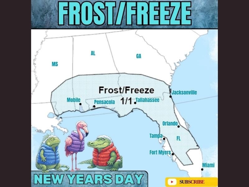
Forecast guidance shows lows dipping into the upper 20s to low 30s across the Panhandle, Big Bend, and a large portion of North Florida. Interior sections of Central Florida may also see frost conditions, while coastal regions will remain slightly milder but still notably chilly for early January.
Coldest Temperatures Arrive Between 3 AM and 8 AM
Meteorologists expect the coldest window to occur during the predawn hours on New Year’s Day, when skies will be clear and winds calmer, allowing temperatures to fall quickly. Areas from Mobile to Pensacola, Tallahassee, Jacksonville, and inland parts of Central Florida appear most at risk of frost or a light freeze.
The combination of radiational cooling and the advancing cold air mass will create conditions that favor widespread frost formation across shaded and low-lying areas. Residents waking up early on Wednesday may find frost on vehicles, rooftops, lawns, and exposed surfaces.
Even locations farther south—such as Orlando, Tampa, and Fort Myers—are expected to feel the chill, with temperatures dropping into the 40s and frost possible just inland from the immediate coastline.
What Residents Should Expect During the Freeze Event
Forecast maps highlight an extensive frost/freeze zone stretching across the northern half of the state. The expected conditions include:
• Lows in the upper 20s to near 30 degrees across the Panhandle and North Florida
• Frost likely in interior Central Florida
• Continued chilly conditions along the Gulf and Atlantic coasts
Residents should take precautions to protect vulnerable plants, as even a few hours of sub-32-degree temperatures can lead to damage. Outdoor pets, livestock, and sensitive plumbing should also be safeguarded during the overnight freeze.
Gardeners and agricultural operations may need to prepare coverings or irrigation measures to limit frost damage, particularly in areas where freezing temperatures are prolonged.
Cold-Stunned Iguanas Possible in South Florida
As temperatures fall across the state, wildlife experts warn that cold-stunned iguanas may become more common in southern regions. When temperatures drop significantly, iguanas can become lethargic and temporarily lose mobility, causing them to fall from trees.
While dramatic, the phenomenon is not unusual during Florida cold snaps and typically resolves once temperatures rise again during the day. Residents are cautioned not to approach or relocate stunned iguanas, as they may suddenly awaken and react defensively when warmed.
Cold Air Pushes Well South Before Gradual Warming Returns
The widespread frost event reflects a deeper push of continental cold air reaching farther south than earlier systems this season. Although Wednesday morning will bring the harshest temperatures, conditions are expected to gradually warm into the afternoon with sunshine returning statewide.
Despite the warming trend later in the week, another round of colder-than-normal temperatures may follow depending on the evolution of the next frontal system approaching the Southeast.
As Florida prepares for a frosty start to the new year, NapervilleLocal.com will continue monitoring temperature trends, local advisories, and potential impacts on communities across the region. Check back for updated forecasts and safety guidance as the cold weather pattern evolves.

I’ve lived in Naperville long enough to see how quickly our community changes — from new developments downtown to sudden shifts in our Midwest weather. Reporting on Naperville news and daily forecasts gives me the chance to keep neighbors informed about what really matters. My goal is simple: deliver clear, timely updates so you always know what’s happening in our city and what to expect from the skies above.