
Florida Could See Rare Flurry Potential Next Weekend as Cold Front Targets the Southern States
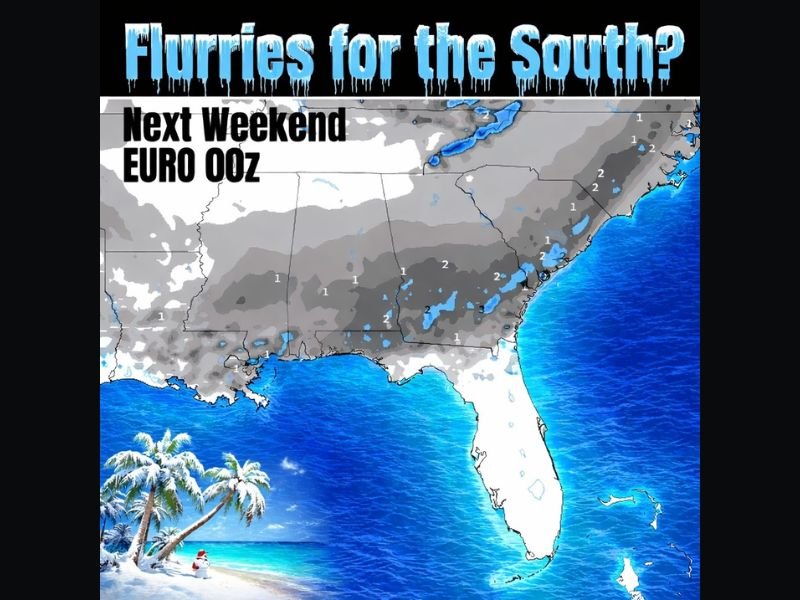
FLORIDA — Long-range weather guidance is beginning to hint at a rare winter scenario for Florida, with the overnight EURO model run keeping the door open for flurry chances across parts of the southern United States next weekend. While this is not a forecast yet, the signal is strong enough to warrant attention as a notable cold front is expected to push south into the region.
Other forecast models remain less aggressive, but the presence of cold air alone is enough to introduce the possibility of brief wintry precipitation if moisture aligns correctly.
Cold Front Timing Will Be the Key Factor
Meteorologists are closely watching the timing and strength of the approaching cold front, which is expected to arrive sometime next week. If the front moves in quickly and moisture is still available, light flurries could develop, particularly during overnight or early morning hours.
At this stage, confidence remains low, but the pattern supports at least a non-zero chance of wintry weather reaching unusually far south.
Moisture Availability Remains the Biggest Question
Cold air alone does not produce snow in Florida. Forecast guidance makes it clear that moisture will be the deciding factor. If moisture fails to materialize, conditions would remain dry and simply colder than normal.
However, if even limited moisture overlaps with the coldest air, brief flurries or light wintry mix could occur in isolated spots, primarily north and inland from the immediate coastline.
Midweek Front Brings Mountain Snow Before Southern Push
Before attention turns fully to Florida, a midweek cold front is still expected to impact the southern Appalachian region. This earlier front will help reinforce the cold pattern and increase confidence that colder air will be available when the late-weekend system arrives. This step-by-step progression is why meteorologists are emphasizing trend tracking rather than snowfall totals at this stage.
Why This Setup Is Being Watched Closely
Snow or flurries in Florida are extremely rare, making any credible signal worth monitoring. While the odds remain low, the pattern supports at least a legitimate conversation rather than outright dismissal. Forecast confidence should improve over the next several days as models converge on timing, moisture availability, and temperature profiles.
NapervilleLocal.com will continue monitoring national weather patterns and explain why developments far from Illinois can still signal meaningful shifts in the overall winter setup across the country.

I’ve lived in Naperville long enough to see how quickly our community changes — from new developments downtown to sudden shifts in our Midwest weather. Reporting on Naperville news and daily forecasts gives me the chance to keep neighbors informed about what really matters. My goal is simple: deliver clear, timely updates so you always know what’s happening in our city and what to expect from the skies above.