
Florida Expected to Largely Avoid Major Winter Storm as Most of the United States Braces for Snow, Ice, and Dangerous Cold This Weekend
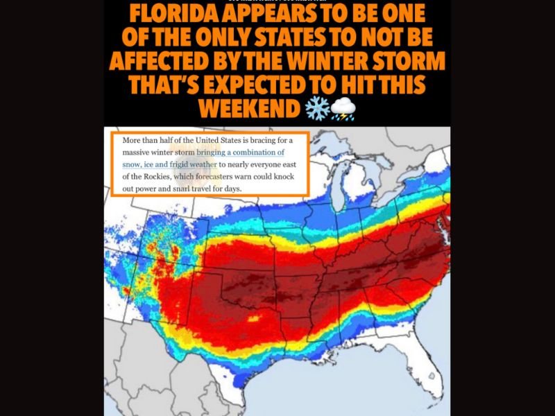
UNITED STATES — A widespread winter storm is expected to impact more than half of the United States this weekend, bringing a dangerous mix of snow, ice, freezing rain, and frigid temperatures to large portions of the country. Forecast data indicates that Florida appears to be one of the only states not significantly affected by the developing system.
Meteorologists describe the setup as a multi-hazard winter event, driven by a southern storm system moving eastward while Arctic air remains firmly in place across much of the nation.
Massive Storm Expected to Impact Regions East of the Rockies
Forecast guidance shows the winter storm affecting nearly everyone east of the Rocky Mountains, with impacts varying by region.
Expected hazards include:
- Heavy snow across colder northern areas
- Ice accumulation in transition zones
- Freezing rain and sleet posing high risks for power outages
- Frigid temperatures following the storm’s passage
Forecasters warn that this combination of hazards could snarl travel and disrupt daily life for several days.
Highest Ice Risk Lies in Central Transition Zone
One of the most dangerous aspects of the storm is a broad transition zone stretching from the central Plains through the Ohio Valley and into the Appalachian region.
In this zone:
- Freezing rain and sleet are possible
- Ice buildup poses the greatest risk to power infrastructure
- Road conditions may deteriorate rapidly
Meteorologists emphasize that ice storms often cause more damage than heavy snow, especially when temperatures drop quickly after precipitation.
Snow Favored in the North, Mixed Precipitation Near the Coast
Farther north, snow is favored across the northern Plains and Upper Midwest, while the Northeast and Mid-Atlantic are expected to see snow inland and rain or mixed precipitation closer to the coast. Final snowfall totals remain highly sensitive to the exact track of the storm, with small shifts potentially changing outcomes dramatically.
Southern States See Cold Rain With Limited Icing
Across much of the southern United States, precipitation is expected to fall mainly as cold rain, though isolated icing cannot be ruled out in parts of Texas and the lower Mississippi Valley. Despite lower snow potential, rapid temperature drops could still create localized travel hazards.
Florida Appears Largely Spared From Winter Impacts
Unlike much of the country, Florida appears to avoid the primary impacts of this winter storm, with no widespread snow or ice threats indicated in current forecasts.
While cooler temperatures and rain are possible, Florida is not expected to experience the hazardous winter conditions forecast elsewhere.
Confidence High in Timing and Scope, Lower in Exact Placement
Forecasters report high confidence in the timing and widespread nature of the storm, but lower confidence in exact snow and ice placement, particularly within the transition zone.
Nationwide concerns include:
- Power outages
- Dangerous travel conditions
- Rapid temperature drops
- Extended recovery periods in hardest-hit regions
Residents across impacted areas are urged to monitor forecasts closely and prepare for rapidly changing winter conditions. For continued national weather coverage and clearly explained forecast updates, follow NapervilleLocal.com.

I’ve lived in Naperville long enough to see how quickly our community changes — from new developments downtown to sudden shifts in our Midwest weather. Reporting on Naperville news and daily forecasts gives me the chance to keep neighbors informed about what really matters. My goal is simple: deliver clear, timely updates so you always know what’s happening in our city and what to expect from the skies above.