
Florida Eyes Much-Needed Rain Relief Next Week as Weak Atlantic Front May Bring Midweek Showers Across Miami, Tampa, Orlando and South Florida
FLORIDA — After a stretch of limited rainfall, parts of Florida could finally see some much-needed precipitation next week, as forecast models indicate a weak frontal boundary may push moisture into the peninsula around midweek.
While this is not expected to be a major rain event, even light showers could provide some relief across South Florida, Central Florida, and coastal regions.
Weak Front May Pull Moisture Into Florida
Forecast guidance from major weather models suggests:
- A weak frontal boundary wrapping around the Atlantic high pressure system
- Moisture being pulled westward into the Florida peninsula
- Rain chances increasing around midweek (March 25–26 timeframe)
This setup is not a strong storm system, but rather a subtle shift in atmospheric flow that could allow scattered showers to develop.
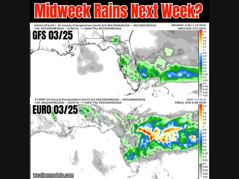
GFS vs EURO: Different Rainfall Expectations
Two leading forecast models are showing slightly different scenarios:
GFS Model (Lighter Rainfall Signal)
- Spotty showers across South Florida and parts of Central Florida
- Rainfall totals generally light and scattered
- Limited coverage across the peninsula
EURO Model (Heavier, More Organized Moisture)
- Broader area of rain, especially across southern and southeastern Florida
- Potential for moderate rainfall pockets offshore and near coastal areas
- Higher rainfall intensity compared to GFS
This difference highlights some uncertainty, but both models agree on at least some level of rain potential.
Focus Areas for Rain Chances
The highest chances for showers appear to be across:
- Miami and South Florida metro areas
- Florida Keys and surrounding waters
- Parts of Tampa Bay and Orlando regions
Rainfall may be uneven, with some areas receiving more than others.
Not a Major Rain Event — But Still Helpful
Forecasters emphasize:
- Rain totals likely on the lower side overall
- No indication of widespread severe weather
- Even light rain could be beneficial given recent dry conditions
This type of pattern is typical when weak fronts interact with Atlantic high pressure.
Timing Still Subject to Change
As the system is still several days out:
- Timing and coverage of rain could shift slightly
- Rain chances may increase or decrease depending on model trends
- Updates will become clearer closer to midweek
Final Outlook
Florida may finally get a break from dry conditions as a weak frontal boundary brings scattered midweek showers next week, especially across South and Central Florida.
While rainfall amounts are expected to remain modest, the potential for moisture returning to the region is a welcome sign for many. Stay tuned to Naperville Local for continued updates on national weather patterns and regional forecast changes.

I’ve lived in Naperville long enough to see how quickly our community changes — from new developments downtown to sudden shifts in our Midwest weather. Reporting on Naperville news and daily forecasts gives me the chance to keep neighbors informed about what really matters. My goal is simple: deliver clear, timely updates so you always know what’s happening in our city and what to expect from the skies above.