
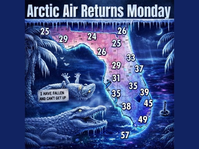
Florida Faces Another Arctic Surge as Temperatures Plunge Overnight and Winter Strikes Back Early Monday
FLORIDA — A brief weekend warmup across the Sunshine State is about to end abruptly as another powerful Arctic cold front charges south late Sunday, sending temperatures crashing overnight and into early Monday morning in what forecasters are calling Round Two of Florida versus Winter.
Meteorologists warn this will be a fast, sharp temperature drop, catching many off guard after milder weekend conditions.
Arctic Air Returns Fast and Aggressive
Forecast data shows Arctic air surging deep into Florida by early Monday, with temperatures falling rapidly after sunset Sunday night.
By Monday morning:
- North Florida is expected to wake up in the low to mid-20s
- Central Florida will dip into the upper-20s to low-30s
- South Florida will cool into the 40s, with some coastal areas staying slightly warmer
This marks another unusual cold morning for mid-winter Florida, especially for inland and northern communities.
Why This Cold Front Feels More Intense
Unlike gradual cooldowns, this front features:
- Strong Arctic air advection
- Rapid nighttime temperature drops
- Little time for homes, plants, and infrastructure to adjust
The sharp plunge explains why forecasters describe temperatures as “dropping like iguanas”, a reference to how sudden cold snaps can impact wildlife in Florida.
Roller-Coaster Weather Pattern Continues
This system reinforces a volatile winter pattern, where warm spells are quickly followed by intense cold outbreaks.
Forecasters note:
- This is not the final cold shot of the season
- Additional swings are possible in the coming weeks
- Confidence is high in Monday morning’s chill, even if daytime recovery follows
Residents are urged not to let the weekend warmth create a false sense of security.
What Residents Should Do Now
With overnight lows dropping quickly:
- Protect plants and exposed pipes
- Bring pets indoors
- Check on neighbors, especially elderly residents
- Limit early-morning travel if frost or slick conditions develop inland
Even areas that stay above freezing will feel dramatically colder due to the rapid change.
Bottom Line
Florida’s brief winter break is ending, and Arctic air is reclaiming the state early Monday. While this won’t be a historic freeze everywhere, the speed and depth of the temperature drop make it impactful, particularly for northern and central Florida.
For continued winter updates, cold-weather alerts, and forecast tracking as this Arctic front moves through, stay with NapervilleLocal.com and check back frequently for the latest weather developments.

I’ve lived in Naperville long enough to see how quickly our community changes — from new developments downtown to sudden shifts in our Midwest weather. Reporting on Naperville news and daily forecasts gives me the chance to keep neighbors informed about what really matters. My goal is simple: deliver clear, timely updates so you always know what’s happening in our city and what to expect from the skies above.