
Florida Faces Brief Cold Shock: Friday Morning Lows Drop Into 20s Across North Florida as Chilly Air Reaches Deep Into Peninsula
FLORIDA — Florida is set to experience a surprising burst of cold air overnight, with a Friday morning temperature map showing unseasonably cold lows across nearly the entire state, including 20s in North Florida and 30s stretching far south into the peninsula before warmer conditions return next week.
The temperature setup is being described as a short-lived but sharp cold snap, catching many off guard after recent mild and spring-like conditions.
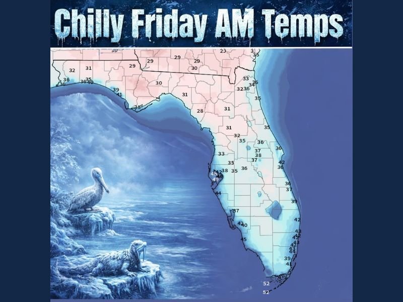
Friday Morning Temperature Map Shows Widespread Chill
The map labeled “Chilly Friday AM Temps” highlights a broad swath of cold air pushing south across Florida.
Key takeaways from the data:
- North Florida: Multiple inland locations drop into the upper 20s, with readings around 28–29°F, signaling a real freeze risk.
- Florida Panhandle: Temperatures largely range from the upper 20s to near 30°F, especially away from the immediate coastline.
- Central Florida: Lows generally fall into the low to mid-30s, cold enough to feel winter-like by Florida standards.
- South Florida: Even areas that usually stay mild are shown in the upper 30s to low 40s, with the Florida Keys near the low 50s.
Coastal locations remain slightly warmer, but the cold penetrates far enough inland to impact most of the state.
Why This Cold Snap Is Notable for Florida
What makes this setup stand out is how far south the cold air reaches. Florida often sees brief winter cold fronts, but this event pushes near-freezing temperatures deep into the peninsula, not just confined to the northern tier.
Because the cold arrives overnight, the coldest window will be early Friday morning, especially near sunrise. This is when exposed plants, pets, and outdoor plumbing are most vulnerable in northern and interior parts of the state.
Cold Is Short-Lived as Warmth Quickly Returns
According to the forecast message included with the map, this cold blast is expected to be brief. After Friday morning, temperatures rebound steadily, with 70s and even some 80s returning next week across much of Florida.
This kind of rapid temperature swing is typical for late winter and early spring in the Southeast—quick shots of cold followed by equally fast warmups.
What Residents and Travelers Should Keep in Mind
For Florida residents, Friday morning will feel more like mid-winter than early spring. Extra layers, protecting sensitive plants, and limiting early outdoor exposure in colder areas may be necessary.
For families in Illinois or the Midwest with travel plans or relatives in Florida, the map is a reminder that Florida is not immune to sharp cold snaps, even when the rest of the country is already thinking about spring.
For more weather updates, national pattern shifts, and seasonal outlooks that affect families with connections across the country, keep following NapervilleLocal.com.

Naperville is a community with stories that deserve to be told — both the serious ones about safety and justice, and the lighter ones that capture our culture and daily life. I focus on covering crime reports and court updates while also highlighting the traditions, events, and social trends that shape who we are. Through my reporting, I want to give readers a fuller picture of Naperville — the challenges we face and the character that keeps our city strong.