
Florida Faces Potential Record-Breaking Cloud-Level Cold as Tampa Bay Approaches Historic Upper-Air Temperatures
FLORIDA — A rare and significant cold air intrusion is unfolding across the state, with meteorologists warning that cloud-level temperatures early Sunday morning could approach or even rival long-standing records, particularly in the Tampa Bay region.
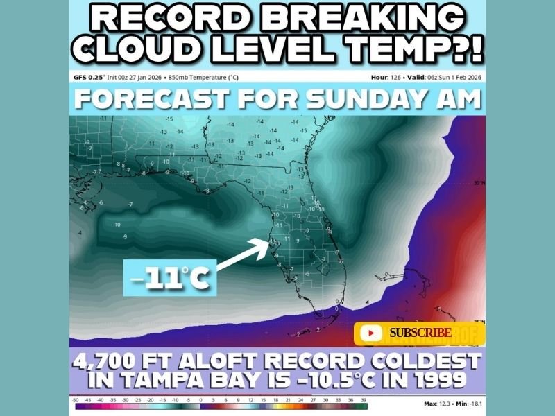
Forecast data indicates that temperatures near the 850 millibar level — roughly 4,700 feet above the surface — may drop to around -11°C, a level of cold rarely observed over Florida and one that has only been recorded a handful of times in decades of observations.
What Makes This Cold Event So Unusual
The 850 mb level represents the lower portion of the cloud layer and is closely monitored by meteorologists to assess the depth and strength of cold air masses. Forecast guidance suggests Sunday morning may feature some of the coldest upper-air temperatures Florida has seen in years.
In Tampa Bay, the standing record for the coldest 850 mb temperature is -10.5°C, set in 1999. Current projections place temperatures at or below that mark, raising the possibility of a new record — even if it may not be officially verified.
Why a Record May Not Be Officially Logged
While the forecast supports near-record or record-breaking cold aloft, verification depends on the timing of weather balloon launches. Upper-air observations are collected only at specific times, and the coldest temperatures may occur outside those observation windows.
As a result, the coldest part of this air mass could pass through undetected by official balloon data, even if it technically meets or exceeds historical thresholds.
How Far Back These Records Go
Upper-air temperature records in Tampa Bay date back to 1948, making any near-record reading a notable event in Florida’s meteorological history. Cold of this magnitude at cloud level underscores just how intense this Arctic air intrusion is, even in areas known for mild winters.
What This Means at the Surface
While this data focuses on temperatures aloft, such extreme cold overhead often supports clearer skies, strong radiational cooling, and the potential for unusually cold surface temperatures, especially during the early morning hours.
Residents across Florida should be prepared for unseasonably cold conditions, particularly around sunrise Sunday, even if snow or ice does not occur. For continued coverage of historic cold events, upper-air records, and major weather developments affecting Florida and beyond, stay with NapervilleLocal.com.

I’ve lived in Naperville long enough to see how quickly our community changes — from new developments downtown to sudden shifts in our Midwest weather. Reporting on Naperville news and daily forecasts gives me the chance to keep neighbors informed about what really matters. My goal is simple: deliver clear, timely updates so you always know what’s happening in our city and what to expect from the skies above.