
Florida Faces Rare and Dangerous Wind Chill Event as Arctic Air Slams State Ahead of Historic Tampa NHL Game
FLORIDA — An unusually intense blast of Arctic air is plunging deep into Florida this weekend, bringing some of the coldest wind chill values the state has experienced in decades, according to long-range European forecast model data. The cold snap arrives just as Tampa prepares to host the first outdoor NHL game in city history, creating an extraordinary weather backdrop for an event more commonly associated with mild winter temperatures.
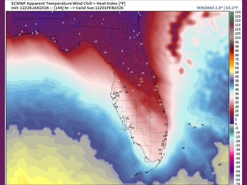
Wind Chills Drop to Single Digits Across North Florida
Forecast wind chill projections for Sunday morning show apparent temperatures falling into the single digits across North Florida, a level rarely seen in the region. Areas along the Interstate 10 corridor are expected to experience wind chills between 0 and 9 degrees, driven by strong north winds funneling Arctic air southward behind a powerful coastal storm system.
These values rival some of the coldest conditions observed in Florida over the past 40 years, underscoring the rarity of the event.
Central Florida Sees Teens Near Major Cities
The cold air mass does not stop in the Panhandle. Central Florida, including areas near Tampa and Orlando, is forecast to experience wind chills in the teens, particularly during the early morning hours on Sunday. Gusty winds will amplify the cold, making it feel far colder than actual air temperatures.
Residents unaccustomed to prolonged cold exposure may face an increased risk of hypothermia, especially during outdoor events or overnight hours.
South Florida Feels the Chill Too
Even South Florida, typically shielded from extreme winter cold, will not escape the impact. Wind chills across Miami and surrounding coastal areas are expected to dip into the 20s, a sharp departure from normal winter conditions. Coastal waters will remain warmer, but inland areas may feel noticeably colder, particularly before sunrise.
Arctic Air Driven by Powerful Eastern Storm System
Meteorologists attribute the cold outbreak to a deepening storm system along the Eastern Seaboard, which is helping to draw Arctic air far south into the southeastern United States. Multiple forecast models support this scenario, increasing confidence that the cold will be both widespread and impactful.
While snow is not guaranteed, upper-level temperatures are cold enough that isolated flurries cannot be completely ruled out, especially in northern sections of the state.
Residents Urged to Prepare for Rare Cold Conditions
With wind chills well below normal, residents are urged to:
- Dress in layers
- Protect pets, plants, and exposed pipes
- Limit prolonged outdoor exposure
- Check on vulnerable neighbors
These precautions are especially important in a region where homes and infrastructure are not designed for extended cold.
For continued coverage of extreme and unusual weather events across the country, stay informed with NapervilleLocal.com and follow our latest updates.

I’ve lived in Naperville long enough to see how quickly our community changes — from new developments downtown to sudden shifts in our Midwest weather. Reporting on Naperville news and daily forecasts gives me the chance to keep neighbors informed about what really matters. My goal is simple: deliver clear, timely updates so you always know what’s happening in our city and what to expect from the skies above.